Canvas Print > North America > United States of America > New York > New York > Maps
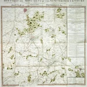
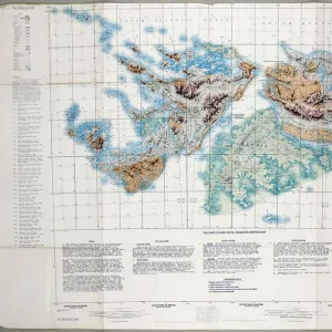
Canvas Print : Minnesota map 1883


![]()
Canvas Prints From Fine Art Storehouse
Minnesota map 1883
Encyclopedia Britannica 9th Edition New York Samuel L. Hall 1883 Vol XVI
Unleash your creativity and transform your space into a visual masterpiece!
THEPALMER
Media ID 14756728
© This content is subject to copyright
20"x16" (51x41cm) Canvas Print
Step back in time with our vintage Minnesota Map Canvas Print from ThePalmer, available at Media Storehouse. This stunning piece of art is taken from the Encyclopedia Britannica 9th Edition, published in New York in 1883 by Samuel L. Hall. The intricate details of the map showcase the geography of Minnesota during that era, making it a unique addition to any home or office. Printed on high-quality canvas, this map art is not only visually appealing but also a conversation starter. Bring a touch of history into your space with Media Storehouse's Minnesota Map Canvas Print.
Delivered stretched and ready to hang our premium quality canvas prints are made from a polyester/cotton blend canvas and stretched over a 1.25" (32mm) kiln dried knot free wood stretcher bar. Packaged in a plastic bag and secured to a cardboard insert for safe transit.
Canvas Prints add colour, depth and texture to any space. Professionally Stretched Canvas over a hidden Wooden Box Frame and Ready to Hang
Estimated Product Size is 40.6cm x 50.8cm (16" x 20")
These are individually made so all sizes are approximate
Artwork printed orientated as per the preview above, with portrait (vertical) orientation to match the source image.
FEATURES IN THESE COLLECTIONS
> Maps and Charts
> Related Images
> North America
> United States of America
> Maps
> North America
> United States of America
> Minnesota
> Related Images
> North America
> United States of America
> New York
> New York
> Maps
> North America
> United States of America
> New York
> Related Images
EDITORS COMMENTS
In this print titled "Minnesota map 1883" we are transported back in time to the late 19th century, where cartography was both a science and an art form. The image showcases a meticulously detailed map of Minnesota, extracted from the renowned Encyclopedia Britannica's 9th Edition published in New York by Samuel L. Hall in 1883. The vintage allure of this piece is undeniable as it offers us a glimpse into the past, revealing how our understanding of geography has evolved over time. Every intricate detail on this map tells a story - from the delicate lines tracing rivers and lakes to the precisely labeled towns and cities that once dotted the landscape. As we explore this historical artifact, we can't help but marvel at its craftsmanship and appreciate its significance as a valuable resource for scholars and enthusiasts alike. The faded colors lend an air of nostalgia, reminding us of an era when maps were cherished possessions that held immense knowledge within their borders. "The Palmer" masterfully captures not only the essence of this antique treasure but also evokes a sense of curiosity about Minnesota's rich history. This print serves as more than just decoration; it becomes a gateway to exploration and discovery for those who dare to delve into its intricacies. Whether displayed in homes or offices, "Minnesota map 1883" invites viewers on an enchanting journey through time while paying homage to both the artistry involved in cartography and our collective human quest for knowledge.
MADE IN THE USA
Safe Shipping with 30 Day Money Back Guarantee
FREE PERSONALISATION*
We are proud to offer a range of customisation features including Personalised Captions, Color Filters and Picture Zoom Tools
SECURE PAYMENTS
We happily accept a wide range of payment options so you can pay for the things you need in the way that is most convenient for you
* Options may vary by product and licensing agreement. Zoomed Pictures can be adjusted in the Basket.