Canvas Print > Historic > Ancient civilizations > Roman Empire > Roman art
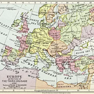
Canvas Print : Map of Germannia, mid-2nd century AD, lithograph, published in 1897


![]()
Canvas Prints from Fine Art Storehouse
Map of Germannia, mid-2nd century AD, lithograph, published in 1897
Map of Germania and the northern provinces of the Roman Empire around the middle of the 2nd century AD. Lithograph, published in 1897
Unleash your creativity and transform your space into a visual masterpiece!
Media ID 15192942
© This content is subject to copyright
20"x16" (51x41cm) Canvas Print
Step back in time with our exquisite Canvas Print of the Map of Germania from Media Storehouse. This captivating piece, taken from a rare 1897 lithograph, showcases the intricate details of the Roman Empire's northern provinces during the mid-2nd century AD. Bring the rich history of ancient civilizations into your home or office, and add an element of timeless sophistication to any space. Our high-quality canvas prints are meticulously crafted to ensure vibrant colors and sharp details, making this a perfect addition to any fine art collection.
Delivered stretched and ready to hang our premium quality canvas prints are made from a polyester/cotton blend canvas and stretched over a 1.25" (32mm) kiln dried knot free wood stretcher bar. Packaged in a plastic bag and secured to a cardboard insert for safe transit.
Canvas Prints add colour, depth and texture to any space. Professionally Stretched Canvas over a hidden Wooden Box Frame and Ready to Hang
Estimated Product Size is 50.8cm x 40.6cm (20" x 16")
These are individually made so all sizes are approximate
Artwork printed orientated as per the preview above, with landscape (horizontal) orientation to match the source image.
FEATURES IN THESE COLLECTIONS
> Arts
> Artists
> R
> Roman Roman
> Historic
> Ancient civilizations
> Roman Empire
> Roman art
> Maps and Charts
> Related Images
> Fine Art Storehouse
> Map
> Map Illustrations
EDITORS COMMENTS
This lithograph, published in 1897, showcases a remarkable Map of Germannia from the mid-2nd century AD. A true testament to the artistry and precision of cartography, this print offers us a glimpse into the ancient world and its intricate geographical boundaries. The map depicts Germania and the northern provinces of the Roman Empire during a pivotal era in history. With delicate strokes and meticulous detailing, it presents an expansive view of territories that were once governed by Rome. From dense forests to winding rivers, every element is intricately portrayed with utmost accuracy. As we study this lithograph, we are transported back in time to an age where empires clashed and cultures intermingled. It allows us to trace the footsteps of ancient civilizations as they navigated through these lands - their triumphs, struggles, and conquests etched upon each contour. Published over a century ago but still retaining its allure today, this print serves as both an educational tool for historians and a work of art for enthusiasts alike. Its vintage aesthetic adds charm while reminding us of our connection to those who came before us. Whether displayed on museum walls or cherished within personal collections, this Map of Germannia lithograph continues to captivate viewers with its historical significance and artistic brilliance.
MADE IN THE USA
Safe Shipping with 30 Day Money Back Guarantee
FREE PERSONALISATION*
We are proud to offer a range of customisation features including Personalised Captions, Color Filters and Picture Zoom Tools
SECURE PAYMENTS
We happily accept a wide range of payment options so you can pay for the things you need in the way that is most convenient for you
* Options may vary by product and licensing agreement. Zoomed Pictures can be adjusted in the Cart.