Canvas Print > Africa > South Africa > Maps
Canvas Print : Vintage illustration Old Map of South Africa, Cape Colony, 1890s, 19th Century


![]()
Canvas Prints from Fine Art Storehouse
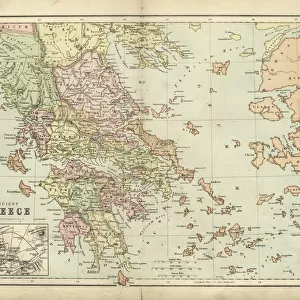
Vintage illustration Old Map of South Africa, Cape Colony, 1890s, 19th Century
Unleash your creativity and transform your space into a visual masterpiece!
duncan1890
Media ID 32108166
20"x16" (51x41cm) Canvas Print
Step back in time with our exquisite Canvas Print of an Old Map of South Africa, Cape Colony, 1890s, 19th Century, from the Fine Art Storehouse by duncan1890. This vintage illustration transports you to a bygone era with intricate detail and rich colors. The textured canvas adds depth and dimension to the intricate lines and bold borders of the map. Perfect for adding a touch of history and character to any room in your home or office. Order now and let this stunning piece of art tell a story of the past.
Delivered stretched and ready to hang our premium quality canvas prints are made from a polyester/cotton blend canvas and stretched over a 1.25" (32mm) kiln dried knot free wood stretcher bar. Packaged in a plastic bag and secured to a cardboard insert for safe transit.
Canvas Prints add colour, depth and texture to any space. Professionally Stretched Canvas over a hidden Wooden Box Frame and Ready to Hang
Estimated Product Size is 50.8cm x 40.6cm (20" x 16")
These are individually made so all sizes are approximate
Artwork printed orientated as per the preview above, with landscape (horizontal) orientation to match the source image.
FEATURES IN THESE COLLECTIONS
> Africa
> South Africa
> Maps
> Africa
> South Africa
> Related Images
> Maps and Charts
> Related Images
> Fine Art Storehouse
> Map
> Historical Maps
EDITORS COMMENTS
This vintage illustration takes us back to the 19th century, specifically to the Cape Colony in South Africa during the 1890s. The intricate details and artistic style of this old map transport us to a time when cartography was not only functional but also an exquisite form of art. The print showcases the vastness and diversity of the Cape Colony, with its rich topography and distinct regions beautifully depicted. From rugged mountain ranges to sprawling coastlines, every element is meticulously drawn, capturing both the grandeur and intricacies of this African land. As we gaze upon this piece, we can't help but imagine explorers using maps like these as they ventured into uncharted territories. It serves as a reminder of how much has changed over time while also highlighting the historical significance that maps hold in our understanding of past civilizations. The sepia tones add a touch of nostalgia, further enhancing our connection to history. This print would be a perfect addition for those who appreciate vintage aesthetics or have an interest in South African history. Whether displayed in a study or living room, it invites viewers on a journey through time and sparks curiosity about what life was like during that era. Duncan1890's skillful reproduction ensures that this vintage illustration remains preserved for generations to come, allowing us all to admire its beauty and immerse ourselves in the fascinating story it tells.
MADE IN THE USA
Safe Shipping with 30 Day Money Back Guarantee
FREE PERSONALISATION*
We are proud to offer a range of customisation features including Personalised Captions, Color Filters and Picture Zoom Tools
SECURE PAYMENTS
We happily accept a wide range of payment options so you can pay for the things you need in the way that is most convenient for you
* Options may vary by product and licensing agreement. Zoomed Pictures can be adjusted in the Cart.