Canvas Print > Europe > Germany > Maps
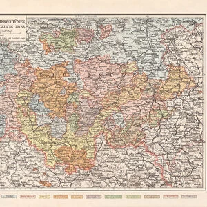
Canvas Print : Map of the Province of Saxony, Germany (1816-1945), lithograph, 1897
, lithograph, 1897")
, lithograph, 1897")

![]()
Canvas Prints From Fine Art Storehouse
Map of the Province of Saxony, Germany (1816-1945), lithograph, 1897
Topographic map of the Province of Saxony (Saxony-Anhalt, Germany), formerly province of the Kingdom of Prussia and later the Free State of Prussia from 1816 until 1945. Lithograph, published in 1897
Unleash your creativity and transform your space into a visual masterpiece!
ZU_09
Media ID 18356563
20"x16" (51x41cm) Canvas Print
Discover the rich history of Saxony, Germany with our stunning Canvas Print of the Topographic Map of the Province of Saxony. This beautiful lithograph, published in 1897, showcases intricate details of the region during the time it was part of the Kingdom of Prussia and later the Free State of Prussia (1816-1945). The Map of Saxony, expertly reproduced on a canvas print, makes an excellent addition to any home or office, transporting you back in time with its historical accuracy and captivating details. Bring a piece of European history into your space with Media Storehouse's Canvas Print of the Map of Saxony.
Delivered stretched and ready to hang our premium quality canvas prints are made from a polyester/cotton blend canvas and stretched over a 1.25" (32mm) kiln dried knot free wood stretcher bar. Packaged in a plastic bag and secured to a cardboard insert for safe transit.
Canvas Prints add colour, depth and texture to any space. Professionally Stretched Canvas over a hidden Wooden Box Frame and Ready to Hang
Estimated Product Size is 50.8cm x 40.6cm (20" x 16")
These are individually made so all sizes are approximate
Artwork printed orientated as per the preview above, with landscape (horizontal) orientation to match the source image.
FEATURES IN THESE COLLECTIONS
> Europe
> Germany
> Related Images
> Maps and Charts
> Related Images
> Fine Art Storehouse
> Map
> Historical Maps
EDITORS COMMENTS
This lithograph, titled "Map of the Province of Saxony, Germany (1816-1945)", takes us on a historical journey through time. Created in 1897 by ZU_09 and now available as a stunning print from Fine Art Storehouse, this topographic map offers a glimpse into the rich past of Saxony-Anhalt. The province depicted in this lithograph was once part of the Kingdom of Prussia before becoming the Free State of Prussia. From 1816 until 1945, it witnessed significant political and social transformations that shaped its identity. The intricate details captured in this map allow us to explore its geographical features with precision and immerse ourselves in an era long gone. As we study this artwork closely, we can appreciate the meticulous craftsmanship involved in creating such a detailed representation. Every contour line and symbol tells a story about the land's topography, rivers, forests, towns, and cities that once thrived within these borders. Beyond being visually appealing, this lithograph serves as both an educational tool for history enthusiasts and an aesthetic addition to any space. Whether displayed at home or in an office setting, it sparks curiosity about how boundaries have evolved over time while reminding us of Saxony-Anhalt's enduring legacy. With its timeless appeal and historical significance preserved through Fine Art Storehouse's high-quality printing techniques, "Map of the Province of Saxony" is sure to captivate admirers seeking to delve into Germany's fascinating past.
MADE IN THE USA
Safe Shipping with 30 Day Money Back Guarantee
FREE PERSONALISATION*
We are proud to offer a range of customisation features including Personalised Captions, Color Filters and Picture Zoom Tools
SECURE PAYMENTS
We happily accept a wide range of payment options so you can pay for the things you need in the way that is most convenient for you
* Options may vary by product and licensing agreement. Zoomed Pictures can be adjusted in the Basket.