Canvas Print > Maps and Charts > Related Images
Canvas Print : Map of New Jersey 1893


![]()
Canvas Prints From Fine Art Storehouse
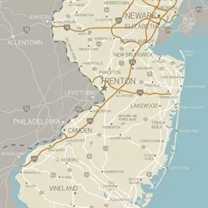
Map of New Jersey 1893
New Pocket Atlas / Rand, McNally & Co -1893
Unleash your creativity and transform your space into a visual masterpiece!
THEPALMER
Media ID 18356705
20"x16" (51x41cm) Canvas Print
Step back in time with our exquisite Canvas Print of the 1893 Map of New Jersey by THEPALMER from the Fine Art Storehouse at Media Storehouse. This captivating piece, taken from the New Pocket Atlas published by Rand, McNally & Co, showcases intricate details of the Garden State's geography as it appeared over a century ago. The vintage map design is beautifully rendered on premium canvas, adding a touch of history and character to any room. Bring a piece of the past into your home and transport yourself on a journey through time with our Canvas Print of the 1893 Map of New Jersey.
Delivered stretched and ready to hang our premium quality canvas prints are made from a polyester/cotton blend canvas and stretched over a 1.25" (32mm) kiln dried knot free wood stretcher bar. Packaged in a plastic bag and secured to a cardboard insert for safe transit.
Canvas Prints add colour, depth and texture to any space. Professionally Stretched Canvas over a hidden Wooden Box Frame and Ready to Hang
Estimated Product Size is 40.6cm x 50.8cm (16" x 20")
These are individually made so all sizes are approximate
Artwork printed orientated as per the preview above, with portrait (vertical) orientation to match the source image.
FEATURES IN THESE COLLECTIONS
> Maps and Charts
> Related Images
> Fine Art Storehouse
> Map
> Historical Maps
EDITORS COMMENTS
In this print titled "Map of New Jersey 1893" we are transported back in time to the late 19th century, where cartography was a true art form. Created by THEPALMER and sourced from Fine Art Storehouse, this vintage map showcases the intricate details and craftsmanship that went into mapping an entire state. The Map of New Jersey takes us on a journey through history, revealing the geographical layout of towns, cities, rivers, and highways as they existed in 1893. The careful precision with which each element is depicted allows us to appreciate the dedication and expertise required to create such a comprehensive representation. As we explore this piece further, our eyes are drawn to the elegant typography used for labeling various locations across the state. Each name carries its own historical significance, reminding us of the rich tapestry of stories embedded within New Jersey's landscape. Beyond its functional purpose as a navigational tool, this map serves as a visual testament to human curiosity and exploration. It invites us to reflect upon how far we have come since those days when maps were essential companions for travelers embarking on uncharted territories. Whether you're an avid historian or simply captivated by vintage aesthetics, "Map of New Jersey 1893" offers an opportunity to immerse yourself in a bygone era while appreciating both artistry and practicality intertwined within one remarkable piece.
MADE IN THE USA
Safe Shipping with 30 Day Money Back Guarantee
FREE PERSONALISATION*
We are proud to offer a range of customisation features including Personalised Captions, Color Filters and Picture Zoom Tools
SECURE PAYMENTS
We happily accept a wide range of payment options so you can pay for the things you need in the way that is most convenient for you
* Options may vary by product and licensing agreement. Zoomed Pictures can be adjusted in the Basket.