Canvas Print > North America > United States of America > New York > New York > Maps
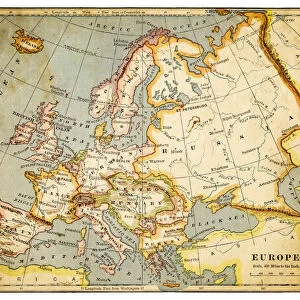
Canvas Print : Map of Europe 1877


![]()
Canvas Prints from Fine Art Storehouse
Map of Europe 1877
The Eclectic Elementary Geography by Wilson & Hinkle / Cincinnati -New York 1881
Unleash your creativity and transform your space into a visual masterpiece!
THEPALMER
Media ID 15133658
© This content is subject to copyright
20"x16" (51x41cm) Canvas Print
Step back in time with our exquisite Canvas Print of the Map of Europe 1877 by THEPALMER from our Media Storehouse Fine Art collection. This captivating vintage map, originally published in "The Eclectic Elementary Geography" by Wilson & Hinkle in 1881, adds an eclectic and educational touch to any room. With intricate details and beautiful antique aesthetics, this Canvas Print is not just a decorative piece, but a window into the past. Bring history to life and transport yourself to a different era with this unique and captivating addition to your home or office.
Delivered stretched and ready to hang our premium quality canvas prints are made from a polyester/cotton blend canvas and stretched over a 1.25" (32mm) kiln dried knot free wood stretcher bar. Packaged in a plastic bag and secured to a cardboard insert for safe transit.
Canvas Prints add colour, depth and texture to any space. Professionally Stretched Canvas over a hidden Wooden Box Frame and Ready to Hang
Estimated Product Size is 50.8cm x 40.6cm (20" x 16")
These are individually made so all sizes are approximate
Artwork printed orientated as per the preview above, with landscape (horizontal) orientation to match the source image.
FEATURES IN THESE COLLECTIONS
> Arts
> Artists
> W
> Wilson Wilson
> Europe
> Related Images
> Maps and Charts
> Related Images
> North America
> United States of America
> New York
> New York
> Maps
> North America
> United States of America
> New York
> Related Images
> Fine Art Storehouse
> Map
> Historical Maps
EDITORS COMMENTS
This print showcases a historical gem, the "Map of Europe 1877" from "The Eclectic Elementary Geography" by Wilson & Hinkle. Published in Cincinnati and New York in 1881, this remarkable piece takes us back to a time when cartography was an art form in itself. The map's intricate details and vibrant colors transport us to the European continent as it stood over a century ago. As we gaze upon this vintage masterpiece, we are reminded of the immense changes that have shaped Europe since then. Each country is meticulously outlined, revealing borders that have shifted with time and history. From the vast Russian Empire stretching across Eastern Europe to the powerful British Isles reigning supreme over their colonies, every nation tells its own story within these lines. Beyond its historical significance, this print also serves as a testament to human curiosity and exploration. It reminds us of our innate desire to understand our world better and navigate through its complexities. As we admire each carefully labeled city and river on this map, we can almost feel ourselves embarking on an imaginary journey through time. "The Map of Europe 1877" by THEPALMER offers not only aesthetic pleasure but also invites contemplation about how far we've come since those days depicted on paper. This artwork captures both our fascination with history and our appreciation for the beauty found within maps themselves – guiding tools that connect us all regardless of time or place.
MADE IN THE USA
Safe Shipping with 30 Day Money Back Guarantee
FREE PERSONALISATION*
We are proud to offer a range of customisation features including Personalised Captions, Color Filters and Picture Zoom Tools
SECURE PAYMENTS
We happily accept a wide range of payment options so you can pay for the things you need in the way that is most convenient for you
* Options may vary by product and licensing agreement. Zoomed Pictures can be adjusted in the Cart.