Canvas Print > Europe > Montenegro > Maps
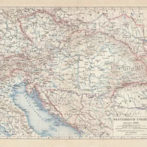
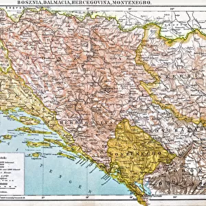
Canvas Print : Map of Bosnia and Montenegro 1900


![]()
Canvas Prints from Fine Art Storehouse
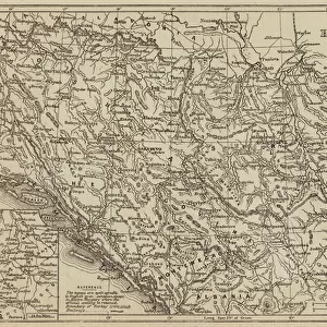
Map of Bosnia and Montenegro 1900
Meyers hand-Atlas Leipzig und Wien Verlag des Bibliographischen Instituts 1900
Unleash your creativity and transform your space into a visual masterpiece!
THEPALMER
Media ID 18356593
20"x16" (51x41cm) Canvas Print
Discover the rich history of Bosnia and Montenegro with our stunning Canvas Print of the Map of Bosnia and Montenegro from THEPALMER's collection at Media Storehouse. This beautiful piece, taken from the Meyers Hand-Atlas published by Bibliographisches Institut Leipzig und Wien Verlag in 1900, is a captivating addition to any home or office. The intricate details of the map are brought to life in vibrant colors and high-quality materials, making it a true work of art. Transport yourself back in time and explore the historical geography of Bosnia and Montenegro with this unique and fascinating canvas print.
Delivered stretched and ready to hang our premium quality canvas prints are made from a polyester/cotton blend canvas and stretched over a 1.25" (32mm) kiln dried knot free wood stretcher bar. Packaged in a plastic bag and secured to a cardboard insert for safe transit.
Canvas Prints add colour, depth and texture to any space. Professionally Stretched Canvas over a hidden Wooden Box Frame and Ready to Hang
Estimated Product Size is 50.8cm x 40.6cm (20" x 16")
These are individually made so all sizes are approximate
Artwork printed orientated as per the preview above, with landscape (horizontal) orientation to match the source image.
FEATURES IN THESE COLLECTIONS
> Europe
> Bosnia and Herzegovina
> Maps
> Europe
> Montenegro
> Maps
> Europe
> Montenegro
> Posters
> Europe
> Montenegro
> Related Images
> Maps and Charts
> Bosnia and Herzegovina
> Maps and Charts
> Montenegro
> Fine Art Storehouse
> Map
> Historical Maps
EDITORS COMMENTS
In this photo print, we are transported back in time to the year 1900, as we explore a meticulously detailed "Map of Bosnia and Montenegro". This exquisite piece is part of the renowned Meyers hand-Atlas collection published by Leipzig und Wien Verlag des Bibliographischen Instituts. The map itself is a testament to the artistry and precision of cartography during that era. Every contour, river, mountain range, and city has been intricately etched onto paper with utmost care. The delicate lines and intricate patterns effortlessly guide our eyes across the sprawling landscape. As we delve into this historical masterpiece, we gain insight into the geopolitical boundaries of Bosnia and Montenegro at the turn of the century. It serves as a window into an era when these regions were still under different political entities but shared cultural ties. The sepia-toned hues lend an air of nostalgia to this print, evoking a sense of reverence for history's unfolding chapters. Each stroke tells a story; each label whispers tales from long ago. "The Map of Bosnia and Montenegro" by THEPALMER captures not only geographical information but also invites us to reflect on how borders have shifted over time. It reminds us that while landscapes may change, maps remain timeless artifacts connecting us to our past. This print is more than just an artistic representation; it is an invitation to embark on a journey through history – one that encourages exploration and sparks curiosity about forgotten lands waiting to be rediscovered.
MADE IN THE USA
Safe Shipping with 30 Day Money Back Guarantee
FREE PERSONALISATION*
We are proud to offer a range of customisation features including Personalised Captions, Color Filters and Picture Zoom Tools
SECURE PAYMENTS
We happily accept a wide range of payment options so you can pay for the things you need in the way that is most convenient for you
* Options may vary by product and licensing agreement. Zoomed Pictures can be adjusted in the Cart.