Canvas Print > Maps and Charts > Related Images
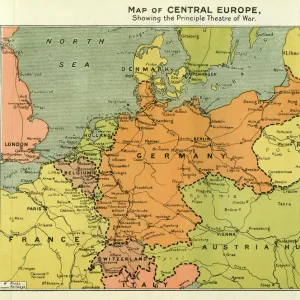
Canvas Print : Central Europe map 1892


![]()
Canvas Prints From Fine Art Storehouse
Central Europe map 1892
Frye Grammar School Geography - 1892
Unleash your creativity and transform your space into a visual masterpiece!
THEPALMER
Media ID 14756020
© This content is subject to copyright
20"x16" (51x41cm) Canvas Print
Step back in time with our exquisite Canvas Print of the Central Europe Map from THEPALMER's Frye Grammar School Geography - 1892 collection. This fine art piece, part of the Media Storehouse's Canvas Prints range, transports you to a bygone era with its intricate details and vintage charm. The map's antique aesthetic, combined with the rich texture of the canvas material, creates a stunning visual that is sure to be a conversation starter in any room. Bring history into your home and add a touch of timeless elegance with this unique and captivating print.
Delivered stretched and ready to hang our premium quality canvas prints are made from a polyester/cotton blend canvas and stretched over a 1.25" (32mm) kiln dried knot free wood stretcher bar. Packaged in a plastic bag and secured to a cardboard insert for safe transit.
Canvas Prints add colour, depth and texture to any space. Professionally Stretched Canvas over a hidden Wooden Box Frame and Ready to Hang
Estimated Product Size is 50.8cm x 40.6cm (20" x 16")
These are individually made so all sizes are approximate
Artwork printed orientated as per the preview above, with landscape (horizontal) orientation to match the source image.
FEATURES IN THESE COLLECTIONS
> Maps and Charts
> Related Images
> Fine Art Storehouse
> Map
> Historical Maps
EDITORS COMMENTS
This print showcases a historical gem, the "Central Europe map 1892 (Frye Grammar School Geography - 1892)" captured by THEPALMER and available at Fine Art Storehouse. Transporting us back to the late 19th century, this meticulously detailed map offers a fascinating glimpse into the geographical landscape of Central Europe during that era. The intricate cartography presents an array of countries, cities, rivers, and mountain ranges that defined this region's rich history. Each line and contour on this vintage map tells a story of exploration, conquests, and cultural exchange. It serves as a testament to the craftsmanship involved in creating such comprehensive representations before modern technology took over. The sepia tones add an air of nostalgia to the image while enhancing its antique charm. This piece is not just an artistic delight but also holds immense educational value for geography enthusiasts or anyone curious about how borders have evolved over time. Whether displayed in a classroom or adorning your home office wall, this print invites you to embark on a visual journey through time. Immerse yourself in the past as you trace trade routes or imagine what life was like for those who inhabited these lands more than a century ago. "The Central Europe map 1892" is more than just decoration; it is an invitation to explore history from an entirely new perspective – one that allows us to appreciate both our present world and how far we've come since then.
MADE IN THE USA
Safe Shipping with 30 Day Money Back Guarantee
FREE PERSONALISATION*
We are proud to offer a range of customisation features including Personalised Captions, Color Filters and Picture Zoom Tools
SECURE PAYMENTS
We happily accept a wide range of payment options so you can pay for the things you need in the way that is most convenient for you
* Options may vary by product and licensing agreement. Zoomed Pictures can be adjusted in the Basket.