Canvas Print > Fine Art Storehouse > Map
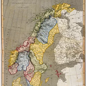
Canvas Print : Antique damaged map of Swden Norway Denmark 19th Century


![]()
Canvas Prints From Fine Art Storehouse
Antique damaged map of Swden Norway Denmark 19th Century
Unleash your creativity and transform your space into a visual masterpiece!
duncan1890
Media ID 13609187
© This content is subject to copyright
Aged Bad Condition Colour Colours Condition Damaged Danish Danish Culture Denmark Equipment Faded Navigational Equipment Nordic Countries Northern Europe Norway Norwegian Norwegian Culture Retro Scandinavia Scandinavian Culture Styles Supplies Sweden Swedish Swedish Culture Traditional Victorian Obsolete Retro Styled Scandinavian Peninsula Victorian Style
20"x16" (51x41cm) Canvas Print
Step back in time with our exquisite antique damaged map of Sweden and Norway, Denmark from the 19th century, expertly curated from the Fine Art Storehouse collection by duncan1890. Each crease, fold, and discoloration tells a story of history, adding character and charm to this unique and captivating piece. Our Canvas Prints faithfully reproduce the intricate details of this vintage map, transforming it into a stunning work of art for your home or office. Relive the past while making a bold statement with this beautiful and distinctive addition to your decor.
Delivered stretched and ready to hang our premium quality canvas prints are made from a polyester/cotton blend canvas and stretched over a 1.25" (32mm) kiln dried knot free wood stretcher bar. Packaged in a plastic bag and secured to a cardboard insert for safe transit.
Canvas Prints add colour, depth and texture to any space. Professionally Stretched Canvas over a hidden Wooden Box Frame and Ready to Hang
Estimated Product Size is 40.6cm x 50.8cm (16" x 20")
These are individually made so all sizes are approximate
Artwork printed orientated as per the preview above, with portrait (vertical) orientation to match the source image.
FEATURES IN THESE COLLECTIONS
> Fine Art Storehouse
> Map
> Denmark Maps
> Fine Art Storehouse
> Map
> Historical Maps
EDITORS COMMENTS
This print showcases an antique damaged map of Sweden, Norway, and Denmark from the 19th century. The worn condition of this historical piece adds a sense of authenticity and charm to its overall appeal. With intricate cartography and vibrant colors that have slightly faded over time, this lithograph is a testament to the rich history of European navigation. The engraving techniques used in creating this map highlight the craftsmanship prevalent during that era. It serves as a reminder of how navigational equipment has evolved since then, rendering such maps obsolete in today's world. Nevertheless, it offers us a glimpse into the past and allows us to appreciate traditional Scandinavian styles. As we delve into the details, we can observe how each country on the Scandinavian Peninsula is depicted with precision and accuracy. This vintage print takes us back to Victorian times when illustration and painting were highly valued forms of artistic expression. Despite its age and damage, this archival photograph captures the essence of Nordic culture - from Norwegian traditions to Danish customs - showcasing their unique identities within Northern Europe. Its vertical composition further enhances its retro-styled aesthetic. For history enthusiasts or those seeking nostalgic decor pieces with character, this antique map print transports you back in time while adding an air of sophistication to any space.
MADE IN THE USA
Safe Shipping with 30 Day Money Back Guarantee
FREE PERSONALISATION*
We are proud to offer a range of customisation features including Personalised Captions, Color Filters and Picture Zoom Tools
SECURE PAYMENTS
We happily accept a wide range of payment options so you can pay for the things you need in the way that is most convenient for you
* Options may vary by product and licensing agreement. Zoomed Pictures can be adjusted in the Basket.