Canvas Print > Europe > Iceland > Maps
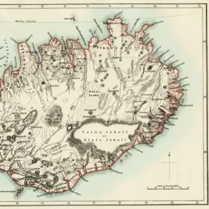
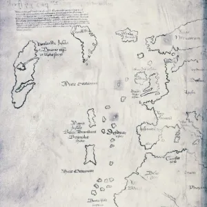
Canvas Print : Iceland map 1881


![]()
Canvas Prints from Fine Art Storehouse
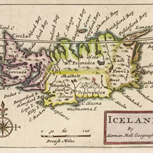
Iceland map 1881
Encyclopedia Britannica 9th Edition Vol XII Philadelphia j.M. Stoddart & Co 1881
Unleash your creativity and transform your space into a visual masterpiece!
THEPALMER
Media ID 13611535
© This content is subject to copyright
20"x16" (51x41cm) Canvas Print
"Step back in time with our exquisite Iceland Map Canvas Print from ThePalmer's Fine Art Storehouse. This captivating piece is a reproduction of an original map from the Encyclopedia Britannica 9th Edition, published by J.M. Stoddart & Co in Philadelphia in 1881. The intricate cartography of Iceland during this era is brought to life in stunning detail on a high-quality canvas, perfect for adding a touch of history and character to any room. Transport yourself to a bygone era with this beautiful and unique work of art."
Delivered stretched and ready to hang our premium quality canvas prints are made from a polyester/cotton blend canvas and stretched over a 1.25" (32mm) kiln dried knot free wood stretcher bar. Packaged in a plastic bag and secured to a cardboard insert for safe transit.
Canvas Prints add colour, depth and texture to any space. Professionally Stretched Canvas over a hidden Wooden Box Frame and Ready to Hang
Estimated Product Size is 50.8cm x 40.6cm (20" x 16")
These are individually made so all sizes are approximate
Artwork printed orientated as per the preview above, with landscape (horizontal) orientation to match the source image.
FEATURES IN THESE COLLECTIONS
> Europe
> Iceland
> Related Images
> Maps and Charts
> Related Images
> Maps and Charts
> World
> North America
> United States of America
> Maps
> Fine Art Storehouse
> The Magical World of Illustration
> Palmer Illustrated Collection
> Fine Art Storehouse
> Map
> Historical Maps
EDITORS COMMENTS
In this print titled "Iceland map 1881" we are transported back in time to the late 19th century, where cartography was a meticulous art form. The image showcases an antique world map from the Encyclopedia Britannica's 9th Edition, Volume XII, published by J. M. Stoddart & Co in Philadelphia in 1881. The intricate engraving and attention to detail on this paper illustration demonstrate the skill of the cartographer who painstakingly crafted this physical geography masterpiece. The map offers a glimpse into Iceland's geographical features as they were understood over a century ago. As we explore this vintage representation of Iceland, our eyes are drawn to its horizontal layout that allows us to appreciate the country's unique shape and position relative to other nations. We can almost feel ourselves tracing our fingers along each contour line and landmark depicted on this historical document. This mesmerizing artwork by THEPALMER invites us to reflect upon how far our understanding of the world has evolved since its creation. It serves as a reminder of both the beauty and complexity inherent in studying maps as tools for exploration and discovery. Whether you are an avid collector of antique prints or simply captivated by history, "Iceland map 1881" is sure to transport you back in time while igniting your curiosity about distant lands and their ever-changing landscapes.
MADE IN THE USA
Safe Shipping with 30 Day Money Back Guarantee
FREE PERSONALISATION*
We are proud to offer a range of customisation features including Personalised Captions, Color Filters and Picture Zoom Tools
SECURE PAYMENTS
We happily accept a wide range of payment options so you can pay for the things you need in the way that is most convenient for you
* Options may vary by product and licensing agreement. Zoomed Pictures can be adjusted in the Cart.