Canvas Print > Arts > Artists > B > Theodore de Bry
Canvas Print : Map of Central and South America, from Americae Tertia Pars


Please select a smaller print size for this image
![]()
Canvas Prints From Fine Art Finder
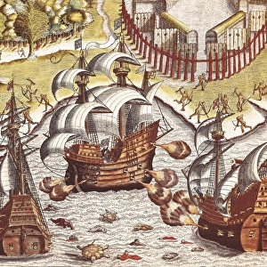
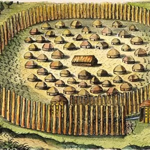
Map of Central and South America, from Americae Tertia Pars
XIR188860 Map of Central and South America, from Americae Tertia Pars.. 1562 (coloured engraving) by Bry, Theodore de (1528-98); Service Historique de la Marine, Vincennes, France; (add.info.: carte de l Amerique Centrale et de l Amerique du Sud; ); Flemish, out of copyright
Media ID 12749450
© www.bridgemanimages.com
20"x16" (51x41cm) Canvas Print
Add a touch of history and culture to your decor with our Canvas Prints from the Media Storehouse range. This stunning piece features the intricately detailed "Map of Central and South America, from Americae Tertia Pars" by Theodore de Bry. Originally published in 1562, this beautifully colored engraving offers a captivating glimpse into the exploration and discovery of the New World. Bring this rich historical artwork into your home or office and elevate the space with its timeless charm and allure.
Delivered stretched and ready to hang our premium quality canvas prints are made from a polyester/cotton blend canvas and stretched over a 1.25" (32mm) kiln dried knot free wood stretcher bar. Packaged in a plastic bag and secured to a cardboard insert for safe transit.
Canvas Prints add colour, depth and texture to any space. Professionally Stretched Canvas over a hidden Wooden Box Frame and Ready to Hang
Estimated Product Size is 50.8cm x 40.6cm (20" x 16")
These are individually made so all sizes are approximate
Artwork printed orientated as per the preview above, with landscape (horizontal) orientation to match the source image.
FEATURES IN THESE COLLECTIONS
> Animals
> Fishes
> Related Images
> Arts
> Artists
> B
> Theodore de Bry
> Maps and Charts
> Related Images
> Maps and Charts
> World
> South America
> Related Images
EDITORS COMMENTS
This vibrant and detailed print showcases a captivating "Map of Central and South America" from the renowned work "Americae Tertia Pars". Created in 1562 by Flemish cartographer Theodore de Bry, this coloured engraving is a true masterpiece that offers a glimpse into the exploration and discovery of the New World. The map itself is rich with intricate details, featuring coat of arms, compasses, and various symbols representing different aspects of this uncharted territory. It beautifully captures the essence of both Central and South America, providing an invaluable historical record for those interested in geography or early colonial history. One can't help but be drawn to the majestic galleon sailing through these unexplored waters. Its presence symbolizes the spirit of adventure and courage that characterized this era. The map also highlights an abundance of fish swimming beneath its surface, reminding us of the region's natural resources and potential wealth. Preserved by France's Service Historique de la Marine in Vincennes, this print serves as a testament to De Bry's exceptional talent as well as his contribution to cartography. Whether you are an avid collector or simply appreciate fine art prints like this one, it undoubtedly holds immense value for anyone fascinated by our world's past.
MADE IN THE USA
Safe Shipping with 30 Day Money Back Guarantee
FREE PERSONALISATION*
We are proud to offer a range of customisation features including Personalised Captions, Color Filters and Picture Zoom Tools
SECURE PAYMENTS
We happily accept a wide range of payment options so you can pay for the things you need in the way that is most convenient for you
* Options may vary by product and licensing agreement. Zoomed Pictures can be adjusted in the Basket.