Canvas Print > North America > Cuba > Guantanamo
Canvas Print : Plan of Guantanamo Bay, Cuba, 1751


![]()
Canvas Prints From Fine Art Finder
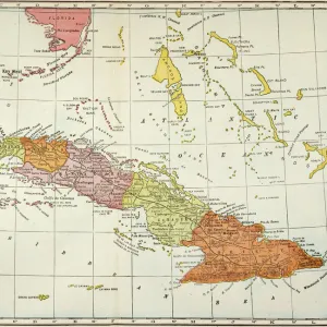
Plan of Guantanamo Bay, Cuba, 1751
2902880 Plan of Guantanamo Bay, Cuba, 1751; (add.info.: Plan of Guantanamo Bay, Cuba, 1751.); Buyenlarge Archive/UIG
Media ID 38414612
© Buyenlarge Archive/UIG / Bridgeman Images
1750s Cartographic Cuba Guantanamo
20"x16" (51x41cm) Canvas Print
Bring a piece of history into your home with this stunning canvas print featuring the "Plan of Guantanamo Bay, Cuba, 1751" by Bridgeman Images from Fine Art Finder. Perfect for adding a touch of vintage charm to any room.
Delivered stretched and ready to hang our premium quality canvas prints are made from a polyester/cotton blend canvas and stretched over a 1.25" (32mm) kiln dried knot free wood stretcher bar. Packaged in a plastic bag and secured to a cardboard insert for safe transit.
Canvas Prints add colour, depth and texture to any space. Professionally Stretched Canvas over a hidden Wooden Box Frame and Ready to Hang
Estimated Product Size is 50.8cm x 40.6cm (20" x 16")
These are individually made so all sizes are approximate
Artwork printed orientated as per the preview above, with landscape (horizontal) orientation to match the source image.
FEATURES IN THESE COLLECTIONS
> Maps and Charts
> Related Images
> North America
> Cuba
> Guantanamo
> North America
> Cuba
> Maps
> North America
> Cuba
> Related Images
> Fine Art Finder
> Artists
> Raymond de la Neziere
EDITORS COMMENTS
This stunning print captures a piece of history with the Plan of Guantanamo Bay, Cuba from 1751. The detailed cartography showcases the layout and geography of this important bay in North America during the 18th century.
The intricate lines and markings on the map provide a glimpse into the past, offering a unique perspective on how this area was navigated and utilized over two centuries ago. From the strategic positioning of buildings to the natural features of the land, every detail is meticulously depicted in this historical document.
As we study this map, we are transported back in time to an era when exploration and colonization were shaping the world as we know it today. The significance of Guantanamo Bay as a key location for trade and military operations is evident in its portrayal on this map.
Whether you are a history buff or simply appreciate fine cartographic artistry, this print is sure to captivate your imagination and spark curiosity about the stories that lie within its borders. It serves as a reminder of our connection to the past and how maps like these have shaped our understanding of geography and culture throughout time.
MADE IN THE USA
Safe Shipping with 30 Day Money Back Guarantee
FREE PERSONALISATION*
We are proud to offer a range of customisation features including Personalised Captions, Color Filters and Picture Zoom Tools
SECURE PAYMENTS
We happily accept a wide range of payment options so you can pay for the things you need in the way that is most convenient for you
* Options may vary by product and licensing agreement. Zoomed Pictures can be adjusted in the Basket.