Canvas Print > Europe > France > Paris > Maps
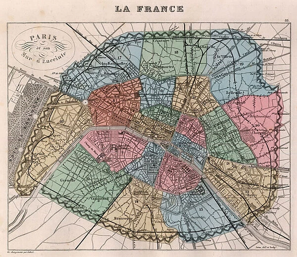
Canvas Print : Map of the city of Paris in 1876. - France and its Colonies. Atlas illustrates one hundred and five maps drawn from the maps of the depot of war, bridges and footwear and the Navy by M. VUILLEMIN. 1876
![]()

Canvas Prints From Fine Art Finder
Map of the city of Paris in 1876. - France and its Colonies. Atlas illustrates one hundred and five maps drawn from the maps of the depot of war, bridges and footwear and the Navy by M. VUILLEMIN. 1876
XEE4144404 Map of the city of Paris in 1876. - France and its Colonies. Atlas illustrates one hundred and five maps drawn from the maps of the depot of war, bridges and footwear and the Navy by M. VUILLEMIN. 1876. by Vuillemin, Alexandre (1812-1886); Private Collection; (add.info.: Map of the city of Paris in 1876. - France and its Colonies. Atlas illustrates one hundred and five maps drawn from the maps of the depot of war, bridges and footwear and the Navy by M. VUILLEMIN. 1876.); Stefano Bianchetti
Media ID 25216668
© Stefano Bianchetti / Bridgeman Images
Alexandre Vuillemin Atlas Book City Map City Plan General Map Street Plan Vuillemin Alexandre 1812 1886
20"x16" (51x41cm) Canvas Print
Step back in time with our exquisite Canvas Print of the Map of Paris in 1876 from the France and its Colonies Atlas. This intricately detailed map, created by M. VUILLEMIN and beautifully reproduced by Stefano Bianchetti, showcases Paris as it looked over a century ago. With one hundred and five maps meticulously drawn from the depots of war, bridges, footwear, and the Navy, this vintage map is a must-have for history enthusiasts and art collectors alike. Add an air of old-world charm to your home or office with this captivating Canvas Print.
Delivered stretched and ready to hang our premium quality canvas prints are made from a polyester/cotton blend canvas and stretched over a 1.25" (32mm) kiln dried knot free wood stretcher bar. Packaged in a plastic bag and secured to a cardboard insert for safe transit.
Canvas Prints add colour, depth and texture to any space. Professionally Stretched Canvas over a hidden Wooden Box Frame and Ready to Hang
Estimated Product Size is 50.8cm x 40.6cm (20" x 16")
These are individually made so all sizes are approximate
Artwork printed orientated as per the preview above, with landscape (horizontal) orientation to match the source image.
FEATURES IN THESE COLLECTIONS
> Arts
> Artists
> Related Images
> Arts
> Portraits
> Pop art gallery
> Street art portraits
> Europe
> France
> Paris
> Maps
> Europe
> France
> Paris
> Related Images
> Maps and Charts
> Early Maps
> Maps and Charts
> Related Images
> Services
> Royal Navy
> Fine Art Finder
> Artists
> Alexandre Vuillemin
> Fine Art Finder
> Artists
> Edme Jean Pigal
EDITORS COMMENTS
This print showcases a beautifully detailed map of the city of Paris in 1876, as part of the larger "France and its Colonies" atlas. Created by Alexandre Vuillemin, a renowned artist and cartographer, this map is one of the highlights from his collection of one hundred and five maps drawn from various sources including the depot of war, bridges and footwear, and the Navy. The intricate details on this map provide a fascinating glimpse into Paris during the late nineteenth century. From its elegant boulevards to its charming neighborhoods, every street plan is meticulously depicted with vibrant colors that bring life to this historical piece. The artist's skillful engraving technique adds depth and dimension to each line and curve. As we explore this map further, we can appreciate not only Vuillemin's artistic talent but also his dedication to accuracy. Every landmark, park, bridge, and building is faithfully represented on this comprehensive city plan. It serves as both an invaluable resource for historians studying urban development in Paris at that time and a visual delight for art enthusiasts. This print captures not just a mere snapshot but rather an exquisite work of art that encapsulates the essence of nineteenth-century France. Whether you are fascinated by history or simply admire fine craftsmanship, this stunning depiction will transport you back in time to experience the grandeur and charm of Paris in 1876.
MADE IN THE USA
Safe Shipping with 30 Day Money Back Guarantee
FREE PERSONALISATION*
We are proud to offer a range of customisation features including Personalised Captions, Color Filters and Picture Zoom Tools
SECURE PAYMENTS
We happily accept a wide range of payment options so you can pay for the things you need in the way that is most convenient for you
* Options may vary by product and licensing agreement. Zoomed Pictures can be adjusted in the Basket.


