Canvas Print > Europe > Italy > Veneto > Rovigo
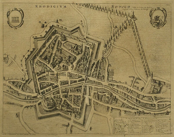
Canvas Print : Map of Rovigo, from Les Villes de Venetie, 1704
![]()

Canvas Prints From Fine Art Finder
Map of Rovigo, from Les Villes de Venetie, 1704
REV345835 Map of Rovigo, from Les Villes de Venetie, 1704, published by Pierre Mortier in Amsterdam (engraving) by Mortier, Pierre (Pieter) (1661-1711); Private Collection; (add.info.: plan de Rovigo; Atlas Nouveau Theatre d Italie ; Johannes Blaeu; Mortier was a printer and engraver in Amsterdam; Venetia; Veneto; Rodigium; Rhodigium; ); French, out of copyright
Media ID 23188902
© Bridgeman Images
Birds Eye Birds Eye View Cartographical Fortifications Fortified Mapping Panorama Rampart Topographical Walls
20"x16" (51x41cm) Canvas Print
Bring the historical charm of old maps into your home with our Canvas Prints from Media Storehouse. This exquisite piece features a detailed and intricately designed Map of Rovigo, taken from "Les Villes de Venetie," published in Amsterdam in 1704. The engraving, created by Pierre Mortier, showcases the city's architectural gems and intricate waterways with stunning precision. Our high-quality canvas prints are carefully crafted to bring out the rich details of this vintage map, making it a unique and captivating addition to any room in your home or office. Order now and travel back in time with every glance.
Delivered stretched and ready to hang our premium quality canvas prints are made from a polyester/cotton blend canvas and stretched over a 1.25" (32mm) kiln dried knot free wood stretcher bar. Packaged in a plastic bag and secured to a cardboard insert for safe transit.
Canvas Prints add colour, depth and texture to any space. Professionally Stretched Canvas over a hidden Wooden Box Frame and Ready to Hang
Estimated Product Size is 50.8cm x 40.6cm (20" x 16")
These are individually made so all sizes are approximate
Artwork printed orientated as per the preview above, with landscape (horizontal) orientation to match the source image.
FEATURES IN THESE COLLECTIONS
> Arts
> Art Movements
> Art Nouveau
> Europe
> Italy
> Veneto
> Related Images
> Europe
> Italy
> Veneto
> Rovigo
> Europe
> Italy
> Veneto
> Venice
> Historic
> Medieval architecture
> Castles and fortresses
> Ancient fortifications
> Maps and Charts
> Italy
> Maps and Charts
> Related Images
> Fine Art Finder
> Artists
> Ambroise Tardieu
> Fine Art Finder
> Artists
> Pierre (1661-1711) Mortier
> Fine Art Finder
> Maps (celestial & Terrestrial)
EDITORS COMMENTS
This print showcases a stunning piece of cartography, the "Map of Rovigo" taken from Les Villes de Venetie in 1704. Published by Pierre Mortier in Amsterdam, this engraving offers a fascinating glimpse into the city's topography and fortifications during that period. The intricate details of this map allow us to explore the city walls, fortification systems, and an index of main buildings within Rovigo. With its birds-eye view perspective, we can almost envision ourselves soaring above the town, taking in every fortified structure and rampart. Rovigo's strategic location within Veneto is highlighted on this map as it served as a crucial stronghold for Venice during that era. The careful mapping not only provides historical insights but also captures the essence of Italian architecture and urban planning at the time. As we delve into this visual treasure trove, we are transported back to 18th-century Europe when Rovigo played a significant role in shaping regional politics and trade routes. This print serves as both an educational tool for historians and art enthusiasts alike while offering a unique glimpse into European history. With its rich detail and exquisite craftsmanship by Pierre Mortier, this Map of Rovigo stands as a testament to his skill as both printer and engraver. It is truly an invaluable addition to any private collection or public display celebrating cartography's beauty.
MADE IN THE USA
Safe Shipping with 30 Day Money Back Guarantee
FREE PERSONALISATION*
We are proud to offer a range of customisation features including Personalised Captions, Color Filters and Picture Zoom Tools
SECURE PAYMENTS
We happily accept a wide range of payment options so you can pay for the things you need in the way that is most convenient for you
* Options may vary by product and licensing agreement. Zoomed Pictures can be adjusted in the Basket.


