Canvas Print > Fine Art Finder > Artists > A > Al Istakhri (10th century)
Canvas Print : Map of the South of Russia and Azerbaijan (vellum)
")
")


Please select a smaller print size for this image
![]()
Canvas Prints from Fine Art Finder
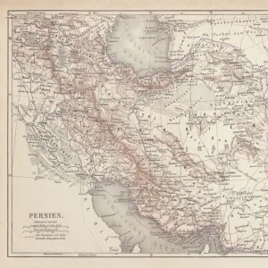
Map of the South of Russia and Azerbaijan (vellum)
XIR370216 Map of the South of Russia and Azerbaijan (vellum) by Al Istakhri (Al-Estakhri) (10th century); Egyptian National Library, Cairo, Egypt; (add.info.: Al-Istakhri was a celebrated 10th century Persian geographer and cartographer; his atlas al-Masalik wa al-Mamalik also gives descriptions of roads. cities, monuments throughout the Islamic world; ); Persian, out of copyright
Media ID 12868720
© www.bridgemanimages.com
Arabic Azerbaidjan C10th Diagram
20"x16" (51x41cm) Canvas Print
Transform your space into a captivating gallery with Media Storehouse Canvas Prints. This exquisite piece features "Map of the South of Russia and Azerbaijan (vellum)" by Al Istakhri (Al-Estakhri) from the Egyptian National Library, Cairo, date back to the 10th century. This stunning fine art print, sourced from Bridgeman Images through Fine Art Finder, showcases the intricate details and rich history of this ancient map. Enhance your home or office décor with this unique and thought-provoking addition to your collection.
Delivered stretched and ready to hang our premium quality canvas prints are made from a polyester/cotton blend canvas and stretched over a 1.25" (32mm) kiln dried knot free wood stretcher bar. Packaged in a plastic bag and secured to a cardboard insert for safe transit.
Canvas Prints add colour, depth and texture to any space. Professionally Stretched Canvas over a hidden Wooden Box Frame and Ready to Hang
Estimated Product Size is 40.6cm x 50.8cm (16" x 20")
These are individually made so all sizes are approximate
Artwork printed orientated as per the preview above, with portrait (vertical) orientation to match the source image.
FEATURES IN THESE COLLECTIONS
> Fine Art Finder
> Artists
> A
> Al Istakhri (10th century)
> Fine Art Finder
> Artists
> Al Istakhri (10th century)
EDITORS COMMENTS
This print showcases a remarkable piece of history, the "Map of the South of Russia and Azerbaijan" created by Al Istakhri in the 10th century. Crafted on vellum, this ancient map is housed in the Egyptian National Library in Cairo, Egypt. Al Istakhri, a celebrated Persian geographer and cartographer, left an indelible mark on Islamic geography with his renowned atlas al-Masalik wa al-Mamalik. The intricate details depicted on this manuscript offer a glimpse into the past, revealing not only geographical information but also descriptions of roads, cities, and monuments throughout the Islamic world. This invaluable resource serves as a testament to Al Istakhri's dedication to documenting and understanding our ever-changing planet. The delicate Arabic script adorning this map adds an element of elegance to its historical significance. Its inclusion of Azerbaijan highlights its importance as a key region within both Russian and Islamic history. As we marvel at this exquisite artifact through Fine Art Finder's lens, let us appreciate not only its aesthetic beauty but also its role in preserving knowledge from centuries ago. It reminds us that maps have always been essential tools for exploration and understanding our world better.
MADE IN THE USA
Safe Shipping with 30 Day Money Back Guarantee
FREE PERSONALISATION*
We are proud to offer a range of customisation features including Personalised Captions, Color Filters and Picture Zoom Tools
SECURE PAYMENTS
We happily accept a wide range of payment options so you can pay for the things you need in the way that is most convenient for you
* Options may vary by product and licensing agreement. Zoomed Pictures can be adjusted in the Cart.