Jigsaw Puzzle : American Civil War. Map of the border between Washington DC
![]()

Jigsaw Puzzles from Mary Evans Picture Library
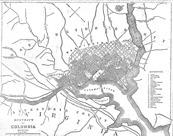
American Civil War. Map of the border between Washington DC
Map from the time of the First Battle of Bull Run, July 21st 1861
Mary Evans Picture Library makes available wonderful images created for people to enjoy over the centuries
Media ID 4376756
© Mary Evans Picture Library 2015 - https://copyrighthub.org/s0/hub1/creation/maryevans/MaryEvansPictureID/10218387
Jigsaw Puzzle (252 Pieces)
Discover history through the captivating experience of our Media Storehouse American Civil War Jigsaw Puzzle. This intricately detailed puzzle features a historical map of the border between Washington D.C. from the time of the First Battle of Bull Run, July 21st, 1861. Reproduced from an authentic antique map sourced from Mary Evans Prints Online, this puzzle brings the past to life in a unique and engaging way. Immerse yourself in the intricacies of this fascinating piece, perfect for history enthusiasts, puzzle lovers, or anyone seeking a challenging and rewarding pastime. Engage in a captivating journey through time as you piece together this vibrant and intricately detailed representation of a pivotal moment in American history.
Made in the USA, 252-piece puzzles measure 11" x 14" (27.9 x 35.5 cm). Every puzzle is meticulously printed on glossy photo paper, which has a strong 1.33 mm thickness. Delivered in a black storage cardboard box, these puzzles are both stylish and practical. (Note: puzzles contain small parts and are not suitable for children under 3 years of age.)
Jigsaw Puzzles are an ideal gift for any occasion
Estimated Product Size is 35.6cm x 28cm (14" x 11")
These are individually made so all sizes are approximate
Artwork printed orientated as per the preview above, with landscape (horizontal) orientation to match the source image.
EDITORS COMMENTS
This historic map, originally published on July 21, 1861, illustrates the border between Washington D.C. and the surrounding Virginia countryside during the early days of the American Civil War. The map was created just one week after the first major battle of the conflict, the First Battle of Bull Run, which took place on July 21, 1861, near Manassas, Virginia. The battle was a significant turning point in the war, as the Confederate Army, led by General P.G.T. Beauregard, defeated the Union Army, led by General Irvin McDowell. The map provides valuable insight into the geography of the region at the time, highlighting key locations such as the Potomac River, the town of Centreville, and the Bull Run stream. The border between the federal district of Washington D.C. and the Confederate-held territory of Virginia is clearly marked, with the map indicating the location of several important forts and military installations. The First Battle of Bull Run marked the end of the optimistic belief that the war would be a short and decisive conflict. The unexpected Confederate victory caused panic in Washington D.C., leading to a rush of volunteers to join the Union Army and a change in military strategy. The map serves as a reminder of the complex and evolving nature of the conflict, as well as the important role that geography played in shaping the outcome of the battle. This map is an essential resource for anyone interested in the history of the American Civil War, providing valuable context and detail about the early stages of the conflict and the strategic importance of the Washington D.C. region. The map is also a testament to the rich historical record that is available through resources such as Mary Evans Prints Online, which offers a vast collection of high-quality historical images for research and educational purposes.
MADE IN THE USA
Safe Shipping with 30 Day Money Back Guarantee
FREE PERSONALISATION*
We are proud to offer a range of customisation features including Personalised Captions, Color Filters and Picture Zoom Tools
FREE COLORIZATION SERVICE
You can choose advanced AI Colorization for this picture at no extra charge!
SECURE PAYMENTS
We happily accept a wide range of payment options so you can pay for the things you need in the way that is most convenient for you
* Options may vary by product and licensing agreement. Zoomed Pictures can be adjusted in the Cart.

