Home > Abstract Art > Landscape
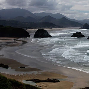
Land area of the State of the Veneto: area of Treviso divided into its territories and districts, engraving by G. Zuliani taken from Tome II of the "Newest Atlas" published in Venice in 1783 by Antonio Zatta, Private Collection

![]()
Wall Art and Photo Gifts from Fondazione Alinari per la Fotografia
Land area of the State of the Veneto: area of Treviso divided into its territories and districts, engraving by G. Zuliani taken from Tome II of the "Newest Atlas" published in Venice in 1783 by Antonio Zatta, Private Collection
Land area of the State of the Veneto: area of Treviso divided into its territories and districts, engraving by G. Zuliani taken from Tome II of the "Newest Atlas" published in Venice in 1783 by Antonio Zatta, Private Collection Florence Engraving Eighteenth Century, Renaissance-Baroque styles and periods, Europe, First and Second Millennium A.D.. Date of Photograph:2009. Date of Artwork:1783. Artist:Zuliani G
Alinari
PDP-A-ZATTA2-0011
Media ID 33185953
© Alinari Archives, Florence
Cartography Drawing And Graphics Geographical Or Topographical Map Geography Graphics Instrument And Document Scene Means Of Communication Territory Abstract Concept And Symbol Concept Or Subject Expressed Landscape Seascape
FEATURES IN THESE COLLECTIONS
> Abstract Art
> Painting
> Related Images
> Arts
> Abstract art
> Abstract landscape paintings
> Arts
> Abstract art
> Arts
> Art Movements
> Baroque
> Arts
> Art Movements
> Seascapes
> Arts
> Contemporary art
> Landscapes
> Abstract art
> Arts
> Contemporary art
> Landscapes
> Seascape paintings
> Arts
> Landscape paintings
> Abstract landscape art
> Landscape paintings
> Arts
> Landscape paintings
> Landscape art
> Abstract landscapes
EDITORS COMMENTS
This print showcases an exquisite engraving from the 18th century, taken from Tome II of the "Newest Atlas" published in Venice in 1783 by Antonio Zatta. The artwork, created by the talented artist G. Zuliani, depicts the land area of Treviso divided into its territories and districts within the State of Veneto. The intricate details and precision of this engraving are truly remarkable, reflecting both Renaissance-Baroque styles and periods prevalent during that era. It serves as a testament to the mastery of cartography and graphics at that time. As we delve into this historical piece, we are transported back to Europe's first and second millennium A. D. , gaining insight into how territories were delineated centuries ago. This topographical map not only provides geographical information but also acts as an allegory for communication and understanding between different regions. The landscape depicted in this artwork is reminiscent of a seascape with its flowing rivers, rolling hills, and charming towns scattered throughout. It offers a glimpse into what life might have been like during that period – bustling communities connected through trade routes and vibrant cultural exchanges. Through this photograph taken in 2009 by Alinari, we can appreciate the enduring beauty of Zuliani's work over two centuries later. It stands as a testament to human curiosity about our surroundings – an instrument documenting our ever-evolving knowledge of geography. This print captures not just a moment frozen in time but also represents an abstract concept symbolizing exploration, discovery, and human ingenuity across generations. Its presence in private collections further emphasizes its significance as both a valuable historical artifact and a stunning piece of artistry deserving admiration for years to come.
MADE IN THE USA
Safe Shipping with 30 Day Money Back Guarantee
FREE PERSONALISATION*
We are proud to offer a range of customisation features including Personalised Captions, Color Filters and Picture Zoom Tools
SECURE PAYMENTS
We happily accept a wide range of payment options so you can pay for the things you need in the way that is most convenient for you
* Options may vary by product and licensing agreement. Zoomed Pictures can be adjusted in the Cart.