Home > Oceania > Australia > Maps
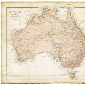
Photographic Print : 1911 Map of Australia
![]()

Photo Prints from Mary Evans Picture Library
1911 Map of Australia
Mary Evans Picture Library makes available wonderful images created for people to enjoy over the centuries
Media ID 4416784
© Mary Evans Picture Library 2015 - https://copyrighthub.org/s0/hub1/creation/maryevans/MaryEvansPictureID/10410250
14"x11" Photo Print
Discover history with our exquisite 1911 Map of Australia print from Media Storehouse. This vintage map, sourced from Mary Evans Prints Online, offers a captivating glimpse into the past with its intricate details and rich colors. Perfect for history enthusiasts, educators, or anyone looking to add a touch of nostalgia to their decor, this rights managed photographic print is a stunning addition to your home or office. With its high-quality print and authentic antique charm, this map of Australia in 1911 is sure to be a conversation starter and a cherished piece in your collection.
Photo prints are produced on Kodak professional photo paper resulting in timeless and breath-taking prints which are also ideal for framing. The colors produced are rich and vivid, with accurate blacks and pristine whites, resulting in prints that are truly timeless and magnificent. Whether you're looking to display your prints in your home, office, or gallery, our range of photographic prints are sure to impress. Dimensions refers to the size of the paper in inches.
Our Photo Prints are in a large range of sizes and are printed on Archival Quality Paper for excellent colour reproduction and longevity. They are ideal for framing (our Framed Prints use these) at a reasonable cost. Alternatives include cheaper Poster Prints and higher quality Fine Art Paper, the choice of which is largely dependant on your budget.
Estimated Image Size (if not cropped) is 35.5cm x 23cm (14" x 9.1")
Estimated Product Size is 35.5cm x 27.9cm (14" x 11")
These are individually made so all sizes are approximate
Artwork printed orientated as per the preview above, with landscape (horizontal) orientation to match the source image.
FEATURES IN THESE COLLECTIONS
> Maps and Charts
> Early Maps
EDITORS COMMENTS
1911 Map of Australia: A Glimpse into the Past This 1911 Map of Australia, presented here as a vintage print, offers an intriguing glimpse into the historical geography and political landscape of the land down under during the early 20th century. The map, created in the midst of the 1910s, reflects the territorial claims and political boundaries that existed during that era. Australia, an island continent located in the Southern Hemisphere, had undergone significant changes in the late 19th and early 20th centuries. The map reveals the vast expanses of the Australian outback, the intricate coastline, and the various territories and colonies that made up the Australian federation. At the turn of the 20th century, Australia had been under British rule for over a century. The map shows the British colonies of Queensland, New South Wales, Victoria, South Australia, Western Australia, Tasmania, and the Northern Territory. The newly established Commonwealth of Australia, which came into existence on January 1, 1901, is depicted as a single entity, encompassing all the colonies except for the Northern Territory and Papua New Guinea. The map also highlights the various exploratory expeditions that had taken place in Australia during the late 19th and early 20th centuries. The names of explorers such as Burke and Wills, Leichhardt, and Sturt are marked on the map, reflecting their significant contributions to the exploration and mapping of the Australian continent. The 1911 Map of Australia serves as an essential historical document, offering insights into the geographical and political landscape of Australia during an era of significant change. It is a testament to the rich history of the land and the explorers who helped shape its modern identity. This print is a must-have for history enthusiasts, geographers, and anyone with an interest in the history of Australia.
MADE IN THE USA
Safe Shipping with 30 Day Money Back Guarantee
FREE PERSONALISATION*
We are proud to offer a range of customisation features including Personalised Captions, Color Filters and Picture Zoom Tools
SECURE PAYMENTS
We happily accept a wide range of payment options so you can pay for the things you need in the way that is most convenient for you
* Options may vary by product and licensing agreement. Zoomed Pictures can be adjusted in the Cart.


