Home > Universal Images Group (UIG) > Art > Painting, Sculpture & Prints > Cartography
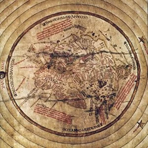
World map by Giovanni Contarini, 1506

![]()
Wall Art and Photo Gifts from Universal Images Group (UIG)
World map by Giovanni Contarini, 1506
Cartography, 16th century. World map created by Giovanni Contarini, 1506
Universal Images Group (UIG) manages distribution for many leading specialist agencies worldwide
Media ID 9571683
© DEA PICTURE LIBRARY
16th Century Africa Direction Guidance Indian Ocean World Map North Pole
EDITORS COMMENTS
This print showcases a remarkable piece of cartographic history - the world map created by Giovanni Contarini in 1506. As we delve into the intricacies of this 16th-century masterpiece, we are transported back in time to an era where exploration and discovery were at their peak. Contarini's map offers us a glimpse into how people perceived the world during that period. With its horizontal orientation, it presents an expansive view of continents and oceans, inviting us to embark on a visual journey across different lands and seas. The attention to detail is awe-inspiring as each region is meticulously depicted with precision and accuracy. From North America to Africa, Europe to the Indian Ocean, this map unfolds before our eyes like a window into the past. It serves not only as a guide for travelers but also as a testament to human curiosity and ambition. The inclusion of physical geography adds depth and dimensionality to this artistic representation. As we gaze upon this image, devoid of any human presence, we are reminded of the vastness of our planet and its rich history waiting to be explored. This artwork by Giovanni Contarini stands as both an illustration of his craftmanship and an homage to the artistry involved in cartography. Thanks to Universal Images Group (UIG), we have been granted access to this extraordinary print that encapsulates centuries-old knowledge within its intricate lines and colors. Let it inspire you with its historical significance while igniting your own sense of wanderlust for adventure beyond borders.
MADE IN THE USA
Safe Shipping with 30 Day Money Back Guarantee
FREE PERSONALISATION*
We are proud to offer a range of customisation features including Personalised Captions, Color Filters and Picture Zoom Tools
SECURE PAYMENTS
We happily accept a wide range of payment options so you can pay for the things you need in the way that is most convenient for you
* Options may vary by product and licensing agreement. Zoomed Pictures can be adjusted in the Cart.