World map. South Pole. Map by Antonius Florianus. Engraving

![]()
Wall Art and Photo Gifts from Mary Evans Picture Library
World map. South Pole. Map by Antonius Florianus. Engraving
World map. South Pole. Map by Antonius Florianus. Engraving by 16th century
Mary Evans Picture Library makes available wonderful images created for people to enjoy over the centuries
Media ID 14337086
© Thaliastock / Mary Evans
Antonius Cartography Earth Geographic Pole Renaissance Terrestrial
EDITORS COMMENTS
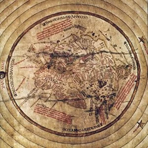
This exquisite 16th century engraving, titled "World Map with the Southern Hemisphere Discovered," is a testament to the groundbreaking cartographic achievements of the Renaissance period. Created by the renowned Italian cartographer Antonius Florianus, this map represents a significant milestone in the exploration and understanding of the Earth's geography. The map, intricately etched onto parchment, is a terrestrial representation of the known world during the late 1500s. It showcases the latest discoveries and advancements in cartography, with a particular focus on the recently explored southern hemisphere. The map's most notable feature is the inclusion of the South Pole, a region that was still largely unknown to Europeans at the time. Antonius Florianus, a master of his craft, meticulously depicted the continents, islands, and bodies of water based on the most accurate information available. His attention to detail is evident in the intricate depiction of coastlines, borders, and topographical features. The map also includes various decorative elements, such as elaborate cartouches and illustrations of exotic animals and people, reflecting the fascination and curiosity of the era. This map holds historical significance as it represents a pivotal moment in the history of cartography. It not only showcases the advancements made during the Renaissance but also serves as a reminder of the ongoing quest for knowledge and discovery. The map's inclusion of the South Pole, a region shrouded in mystery, demonstrates the boldness and ambition of the cartographers of the time, pushing the boundaries of what was known and charted.
MADE IN THE USA
Safe Shipping with 30 Day Money Back Guarantee
FREE PERSONALISATION*
We are proud to offer a range of customisation features including Personalised Captions, Color Filters and Picture Zoom Tools
SECURE PAYMENTS
We happily accept a wide range of payment options so you can pay for the things you need in the way that is most convenient for you
* Options may vary by product and licensing agreement. Zoomed Pictures can be adjusted in the Cart.