Premium Framed Print > Animals > Mammals > Muridae > Desert Mouse
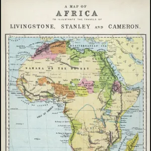
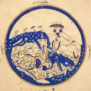
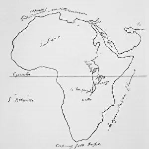
Premium Framed Print : Map of Africa illustrating travels of explorers


![]()
Framed Photos from Mary Evans Picture Library
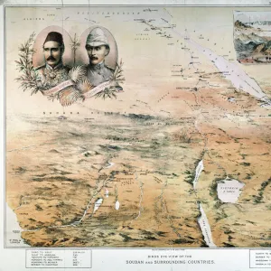
Map of Africa illustrating travels of explorers
A map of Africa which illustrates the travels of the explorers Livingstone, Stanley and Cameron
Mary Evans Picture Library makes available wonderful images created for people to enjoy over the centuries
Media ID 4307227
© Mary Evans Picture Library 2015 - https://copyrighthub.org/s0/hub1/creation/maryevans/MaryEvansPictureID/10007167
Arabia Cameron Cartography Coding Desert Exploration Explorer Explorers Illustrating Living Stone Madagascar Maps Mediterranean Nubia Persia Sahara Stanley Sudan Travels
14"x16" Premium Frame
Contemporary style Premium Wooden Frame with 8"x10" Print. Complete with 2" White Mat and 1.25" thick MDF frame. Printed on 260 gsm premium paper. Glazed with shatter proof UV coated acrylic glass. Backing is paper covered backing with rubber bumpers. Supplied ready to hang with a pre-installed sawtooth/wire hanger. Care Instructions: Spot clean with a damp cloth. Securely packaged in a clear plastic bag and envelope in a reinforced cardboard shipper
FSC Real Wood Frame and Double Mounted with White Conservation Mountboard - Professionally Made and Ready to Hang
Estimated Image Size (if not cropped) is 20.3cm x 25.4cm (8" x 10")
Estimated Product Size is 35.6cm x 40.6cm (14" x 16")
These are individually made so all sizes are approximate
Artwork printed orientated as per the preview above, with portrait (vertical) orientation to match the source image.
FEATURES IN THESE COLLECTIONS
> Africa
> Egypt
> Related Images
> Africa
> Madagascar
> Maps
> Africa
> Madagascar
> Related Images
> Africa
> Related Images
> Africa
> Sudan
> Related Images
> Animals
> Mammals
> Muridae
> Desert Mouse
> Arts
> Artists
> O
> Oceanic Oceanic
EDITORS COMMENTS
This print showcases a detailed "Map of Africa illustrating travels of explorers" from the 19th century. The map highlights the incredible journeys of renowned explorers such as Livingstone, Stanley, and Cameron through various regions including Egypt, Sudan, Nubia, Sahara Desert, Madagascar, and beyond.
Each line on the map represents the path taken by these intrepid adventurers as they navigated their way through uncharted territories in search of new discoveries and knowledge. The vibrant colors used in this historical cartography piece bring to life the spirit of exploration that defined this era.
From traversing vast deserts to sailing across treacherous seas, these Victorian-era explorers braved all obstacles in their quest for adventure and understanding. Their travels not only shaped our understanding of African geography but also inspired future generations to push boundaries and explore unknown lands.
As we study this intricate map filled with coding symbols and geographical markers, we are reminded of the courage and determination exhibited by these fearless individuals who paved the way for modern-day exploration. This Map of Africa is a testament to human curiosity and resilience in the face of adversity - a true masterpiece that captures the essence of discovery in its purest form.
MADE IN THE USA
Safe Shipping with 30 Day Money Back Guarantee
FREE PERSONALISATION*
We are proud to offer a range of customisation features including Personalised Captions, Color Filters and Picture Zoom Tools
SECURE PAYMENTS
We happily accept a wide range of payment options so you can pay for the things you need in the way that is most convenient for you
* Options may vary by product and licensing agreement. Zoomed Pictures can be adjusted in the Cart.