Premium Framed Print > Maps and Charts > Africa
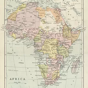
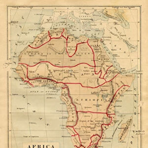
Premium Framed Print : MAP / AFRICA 1842


![]()
Framed Photos from Mary Evans Picture Library
MAP / AFRICA 1842
Map of Africa
Mary Evans Picture Library makes available wonderful images created for people to enjoy over the centuries
Media ID 4357653
© Mary Evans Picture Library 2015 - https://copyrighthub.org/s0/hub1/creation/maryevans/MaryEvansPictureID/10113832
14"x16" Premium Frame
Contemporary style Premium Wooden Frame with 8"x10" Print. Complete with 2" White Mat and 1.25" thick MDF frame. Printed on 260 gsm premium paper. Glazed with shatter proof UV coated acrylic glass. Backing is paper covered backing with rubber bumpers. Supplied ready to hang with a pre-installed sawtooth/wire hanger. Care Instructions: Spot clean with a damp cloth. Securely packaged in a clear plastic bag and envelope in a reinforced cardboard shipper
FSC Real Wood Frame and Double Mounted with White Conservation Mountboard - Professionally Made and Ready to Hang
Estimated Image Size (if not cropped) is 20.3cm x 25.4cm (8" x 10")
Estimated Product Size is 35.6cm x 40.6cm (14" x 16")
These are individually made so all sizes are approximate
Artwork printed orientated as per the preview above, with portrait (vertical) orientation to match the source image.
FEATURES IN THESE COLLECTIONS
> Africa
> Related Images
> Maps and Charts
> Early Maps
> Maps and Charts
> Related Images
EDITORS COMMENTS
This stunning print of a historical map of Africa from 1842 offers a fascinating glimpse into the continent's past. The intricate details and vibrant colors bring to life the diverse landscapes and cultures that have shaped Africa throughout history.
As we study this map, we can see how borders have shifted, nations have risen and fallen, and civilizations have flourished over time. Each line and symbol on the map tells a story of exploration, conquest, trade, and migration that has left its mark on the African continent.
From the mighty Nile River winding through Egypt to the vast deserts of the Sahara stretching across North Africa, this map captures the rich tapestry of geography that defines Africa. It also highlights key cities, regions, and landmarks that were significant in 1842 but may look quite different today.
Whether you are a history buff, a cartography enthusiast, or simply curious about Africa's past, this print is sure to spark your imagination and ignite your sense of wonder. It serves as a reminder of how much our world has changed over time while also celebrating the enduring beauty and complexity of Africa's heritage.
MADE IN THE USA
Safe Shipping with 30 Day Money Back Guarantee
FREE PERSONALISATION*
We are proud to offer a range of customisation features including Personalised Captions, Color Filters and Picture Zoom Tools
SECURE PAYMENTS
We happily accept a wide range of payment options so you can pay for the things you need in the way that is most convenient for you
* Options may vary by product and licensing agreement. Zoomed Pictures can be adjusted in the Cart.