Poster Print > Universal Images Group (UIG) > Universal Images Group > Satellite and Aerial > Planet Observer 4
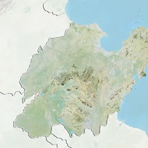
Poster Print : Province of Liaoning, China, Relief Map


![]()
Poster Prints from Universal Images Group (UIG)
Province of Liaoning, China, Relief Map
Relief map of the province of Liaoning, China. This image was compiled from data acquired by LANDSAT 5 & 7 satellites combined with elevation data
Universal Images Group (UIG) manages distribution for many leading specialist agencies worldwide
Media ID 9592261
© Planet Observer/UIG
China Coastline Liaoning Province Relief Map Shore Satellite View
18x24 inch Poster Print
Discover the intricacies of the Province of Liaoning, China, with our stunning Relief Map Poster Print from Media Storehouse. Meticulously created using data from LANDSAT 5 & 7 satellites, this poster provides an accurate and visually appealing representation of the region's topography. Perfect for educational settings, offices, or personal use, this relief map is a captivating addition to any space. Bring the beauty of geography into your home or workplace with Media Storehouse's high-quality, detailed poster prints.
Poster prints are budget friendly enlarged prints in standard poster paper sizes. Printed on 150 gsm Matte Paper for a natural feel and supplied rolled in a tube. Great for framing and should last many years. To clean wipe with a microfiber, non-abrasive cloth or napkin. Our Archival Quality Photo Prints and Fine Art Paper Prints are printed on higher quality paper and the choice of which largely depends on your budget.
Poster prints are budget friendly enlarged prints in standard poster paper sizes (A0, A1, A2, A3 etc). Whilst poster paper is sometimes thinner and less durable than our other paper types, they are still ok for framing and should last many years. Our Archival Quality Photo Prints and Fine Art Paper Prints are printed on higher quality paper and the choice of which largely depends on your budget.
Estimated Product Size is 46.3cm x 61.6cm (18.2" x 24.3")
These are individually made so all sizes are approximate
Artwork printed orientated as per the preview above, with portrait (vertical) orientation to match the source image.
EDITORS COMMENTS
This print showcases the stunning topography of the Province of Liaoning in China. The relief map, compiled from data acquired by LANDSAT 5 & 7 satellites combined with elevation data, offers a unique perspective on this region's physical geography. With its vibrant colors and intricate details, this image provides an immersive experience into the province's diverse landscape. Stretching along the coastline, Liaoning boasts a mesmerizing blend of mountains, valleys, and shorelines. From towering peaks to gentle slopes that gradually meet the sea, this photograph captures the essence of Liaoning's natural beauty. The vertical composition allows viewers to appreciate the province's vastness while highlighting its coastal features. Cartography enthusiasts will be captivated by this detailed representation of Liaoning's terrain. Every contour is meticulously depicted through varying shades and textures, creating a visually striking piece of art that doubles as an informative map. With no people present in the frame, one can fully immerse themselves in exploring every inch of this remarkable landscape without any distractions. This print serves as a window into Asia's rich geographical diversity and invites viewers to embark on their own virtual journey through Liaoning Province
MADE IN THE USA
Safe Shipping with 30 Day Money Back Guarantee
FREE PERSONALISATION*
We are proud to offer a range of customisation features including Personalised Captions, Color Filters and Picture Zoom Tools
SECURE PAYMENTS
We happily accept a wide range of payment options so you can pay for the things you need in the way that is most convenient for you
* Options may vary by product and licensing agreement. Zoomed Pictures can be adjusted in the Cart.