Poster Print > North Wind Picture Archives > Maps
Poster Print : GMDE2A-00054


![]()
Poster Prints from North Wind
GMDE2A-00054
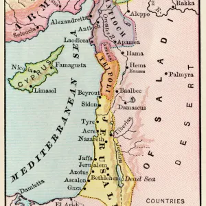
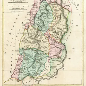
Map of Arabia, 1870s.
Printed color lithograph, 19th century
North Wind Picture Archives brings history to life with stock images and hand-colored illustrations
Media ID 5882247
© North Wind Picture Archives
1870s Arab Arabia Mid East Middle East Territory Arabian Peninsula Gulf Of Aden Persian Gulf Red Sea
18x24 inch Poster Print
"Bring history to life with Media Storehouse's stunning poster prints from North Wind Picture Archives. This captivating piece, GMDE2A-00054, showcases a vibrant and detailed map of Arabia from the 1870s. Printed in the 19th century using traditional color lithography techniques, this poster is a beautiful addition to any home or office. Transport yourself back in time and explore the rich history of this fascinating region. Order now and let this exquisite piece of history adorn your walls."
Poster prints are budget friendly enlarged prints in standard poster paper sizes. Printed on 150 gsm Matte Paper for a natural feel and supplied rolled in a tube. Great for framing and should last many years. To clean wipe with a microfiber, non-abrasive cloth or napkin. Our Archival Quality Photo Prints and Fine Art Paper Prints are printed on higher quality paper and the choice of which largely depends on your budget.
Poster prints are budget friendly enlarged prints in standard poster paper sizes (A0, A1, A2, A3 etc). Whilst poster paper is sometimes thinner and less durable than our other paper types, they are still ok for framing and should last many years. Our Archival Quality Photo Prints and Fine Art Paper Prints are printed on higher quality paper and the choice of which largely depends on your budget.
Estimated Product Size is 46.3cm x 61.6cm (18.2" x 24.3")
These are individually made so all sizes are approximate
Artwork printed orientated as per the preview above, with portrait (vertical) orientation to match the source image.
FEATURES IN THESE COLLECTIONS
> North Wind Picture Archives
> Maps
> North Wind Picture Archives
> Mideast history
> Maps and Charts
> Related Images
EDITORS COMMENTS
This vintage print, titled "GMDE2A-00054 (Map of Arabia, 1870s)" takes us on a journey back to the 19th century. With its traditional and historic allure, this illustration serves as a captivating window into the past. The map showcases the intricate details of the Arabian Peninsula, revealing its vast territory and rich history. The vibrant printed color lithograph brings to life the Middle East's enchanting landscapes and ancient landmarks. From the Red Sea to the Persian Gulf, every contour is meticulously depicted with artistic finesse. This artwork encapsulates not only geographical accuracy but also cultural significance. As we delve deeper into this mesmerizing piece, we are transported through time to an era when exploration was at its peak. The Gulf of Aden sparkles under our gaze while evoking tales of maritime adventures that once unfolded in these waters. Beyond being a mere map, this artful creation embodies an amalgamation of historical documentation and aesthetic beauty. Its portrayal of Arabia in the 1870s offers us glimpses into how borders were defined during that period and provides valuable insights into geopolitical dynamics. Whether you are an art enthusiast or a history buff, this exquisite print from North Wind Picture Archives will undoubtedly captivate your imagination with its intricate detailing and evoke curiosity about bygone times in one of the world's most fascinating regions - Arabia.
MADE IN THE USA
Safe Shipping with 30 Day Money Back Guarantee
FREE PERSONALISATION*
We are proud to offer a range of customisation features including Personalised Captions, Color Filters and Picture Zoom Tools
SECURE PAYMENTS
We happily accept a wide range of payment options so you can pay for the things you need in the way that is most convenient for you
* Options may vary by product and licensing agreement. Zoomed Pictures can be adjusted in the Cart.