Poster Print : Ottoman Map of Lebanon


![]()
Poster Prints from Mary Evans Picture Library
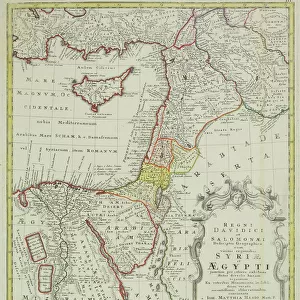
Ottoman Map of Lebanon
Ottoman Map of Lebanon Date: circa 1910
Mary Evans Picture Library makes available wonderful images created for people to enjoy over the centuries
Media ID 7211535
© Mary Evans Picture Library 2015 - https://copyrighthub.org/s0/hub1/creation/maryevans/MaryEvansPictureID/10425703
18x24 inch Poster Print
"Discover the rich history of Lebanon with our exquisite Ottoman Map of Lebanon print from Media Storehouse. This beautifully detailed antique map, dating back to circa 1910, showcases the Ottoman Empire's territories in Lebanon during that era. Meticulously sourced from Mary Evans Prints Online, this rights managed image brings a touch of history and culture to your home or office. Enhance your decor with this unique and captivating piece of art that is sure to spark conversation and inspire curiosity."
Poster prints are budget friendly enlarged prints in standard poster paper sizes. Printed on 150 gsm Matte Paper for a natural feel and supplied rolled in a tube. Great for framing and should last many years. To clean wipe with a microfiber, non-abrasive cloth or napkin. Our Archival Quality Photo Prints and Fine Art Paper Prints are printed on higher quality paper and the choice of which largely depends on your budget.
Poster prints are budget friendly enlarged prints in standard poster paper sizes (A0, A1, A2, A3 etc). Whilst poster paper is sometimes thinner and less durable than our other paper types, they are still ok for framing and should last many years. Our Archival Quality Photo Prints and Fine Art Paper Prints are printed on higher quality paper and the choice of which largely depends on your budget.
Estimated Image Size (if not cropped) is 39.8cm x 61.5cm (15.7" x 24.2")
Estimated Product Size is 46.3cm x 61.6cm (18.2" x 24.3")
These are individually made so all sizes are approximate
Artwork printed orientated as per the preview above, with portrait (vertical) orientation to match the source image.
EDITORS COMMENTS
This Ottoman Map of Lebanon, dating back to approximately 1910, offers a fascinating glimpse into the historical geography of the region during the late Ottoman Empire. The map, which features Cyprus as well, is a testament to the intricate detail and meticulous craftsmanship of Ottoman cartography. The map's vibrant colors and ornate border design reflect the rich cultural heritage of the Ottoman Empire, which ruled much of the Mediterranean world from the 13th to the early 20th centuries. The map's title, written in elegant Arabic script, is flanked by intricate floral and geometric motifs, adding to its visual appeal. The map itself is a detailed representation of the geography of Lebanon and Cyprus during the Ottoman period. The topography is depicted with a high degree of accuracy, with mountains, rivers, and coastlines clearly marked. The map also includes various place names, some of which are still in use today, providing valuable historical context. The Ottoman Map of Lebanon offers a unique perspective on the region's history, allowing us to explore the complex political and geographical landscape of the late Ottoman Empire. It also serves as a reminder of the rich cultural heritage that continues to shape the Middle East and Mediterranean world today. This map is an essential resource for historians, geographers, and anyone with an interest in the history of the Middle East and the Mediterranean region. Its intricate detail and historical significance make it a valuable addition to any collection, and a beautiful piece of art to display in any home or office.
MADE IN THE USA
Safe Shipping with 30 Day Money Back Guarantee
FREE PERSONALISATION*
We are proud to offer a range of customisation features including Personalised Captions, Color Filters and Picture Zoom Tools
SECURE PAYMENTS
We happily accept a wide range of payment options so you can pay for the things you need in the way that is most convenient for you
* Options may vary by product and licensing agreement. Zoomed Pictures can be adjusted in the Cart.