Poster Print > Arts > Artists > T > Tasman
Poster Print : Maps / New Zealand


![]()
Poster Prints from Mary Evans Picture Library
Maps / New Zealand
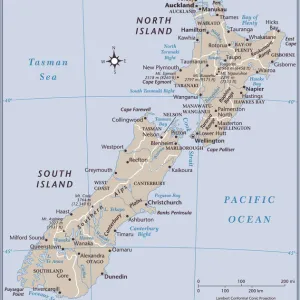
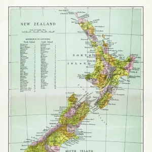
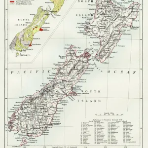
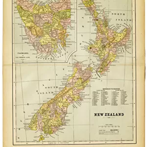
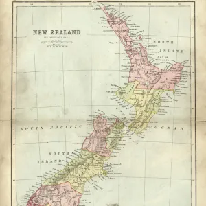
A map of New Zealand Date: 1908
Mary Evans Picture Library makes available wonderful images created for people to enjoy over the centuries
Media ID 7148349
© Mary Evans Picture Library 2015 - https://copyrighthub.org/s0/hub1/creation/maryevans/MaryEvansPictureID/10149914
18x24 inch Poster Print
Discover the captivating beauty of New Zealand with our exquisite Map Poster Print from Media Storehouse. This vintage map, dated 1908, showcases New Zealand in intricate detail, transporting you back in time. Sourced from the extensive collection at Mary Evans Prints Online, this rights managed image brings history to life in your home or office. Add a touch of nostalgia and geographical charm with our Map Poster Print of New Zealand.
Poster prints are budget friendly enlarged prints in standard poster paper sizes. Printed on 150 gsm Matte Paper for a natural feel and supplied rolled in a tube. Great for framing and should last many years. To clean wipe with a microfiber, non-abrasive cloth or napkin. Our Archival Quality Photo Prints and Fine Art Paper Prints are printed on higher quality paper and the choice of which largely depends on your budget.
Poster prints are budget friendly enlarged prints in standard poster paper sizes (A0, A1, A2, A3 etc). Whilst poster paper is sometimes thinner and less durable than our other paper types, they are still ok for framing and should last many years. Our Archival Quality Photo Prints and Fine Art Paper Prints are printed on higher quality paper and the choice of which largely depends on your budget.
Estimated Product Size is 46.3cm x 61.6cm (18.2" x 24.3")
These are individually made so all sizes are approximate
Artwork printed orientated as per the preview above, with portrait (vertical) orientation to match the source image.
FEATURES IN THESE COLLECTIONS
> Maps and Charts
> Related Images
> Oceania
> New Zealand
> Maps
> Oceania
> New Zealand
> Related Images
> Popular Themes
> North Island
EDITORS COMMENTS
1. Title: "Vintage Map of New Zealand from 1908: A Journey Through Time to the Pacific Island Nation's Early Cartographic History" This vintage map print, dated 1908, showcases the intricate detail and historical significance of New Zealand's cartographic evolution. The map, which depicts the islands of New Zealand and its surrounding waters, is a testament to the rich maritime history of this Pacific nation. New Zealand, an archipelago of more than 700 islands, is located in the southwestern Pacific Ocean. The map, published in 1908, illustrates the islands' geographical features with remarkable accuracy for the time. The North and South Islands, the two largest islands, are clearly marked, along with numerous smaller islands scattered throughout the waters. The map also highlights the Tasman Sea, which separates New Zealand from Australia to the west, and the Pacific Ocean to the east. The Cook Strait, the narrow body of water that separates the North and South Islands, is also clearly marked. The map's title, "New Zealand and its Islands," is positioned at the top, while the scale of the map and the cartographer's name, "J.H. Colquhoun," are located at the bottom. This map, produced over a century ago, offers a fascinating glimpse into the cartographic history of New Zealand. It reflects the advancements in mapping technology and the growing European interest in exploring the Pacific region during the late 19th and early 20th centuries. The map's intricate detail and historical significance make it an essential addition to any collection focusing on New Zealand, Pacific Island history, or cartography. In conclusion, this vintage map print of New Zealand from 1908 is a captivating piece of cartographic history that offers a unique perspective on the geography and maritime exploration of this fascinating Pacific nation.
MADE IN THE USA
Safe Shipping with 30 Day Money Back Guarantee
FREE PERSONALISATION*
We are proud to offer a range of customisation features including Personalised Captions, Color Filters and Picture Zoom Tools
SECURE PAYMENTS
We happily accept a wide range of payment options so you can pay for the things you need in the way that is most convenient for you
* Options may vary by product and licensing agreement. Zoomed Pictures can be adjusted in the Cart.