Poster Print > Europe > United Kingdom > England > Kent > Walmer
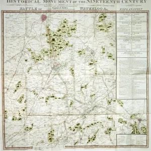
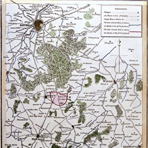
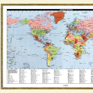
Poster Print : Battle of Waterloo map J020089


![]()
Poster Prints from Historic England
Battle of Waterloo map J020089
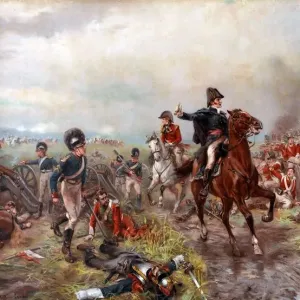
WALMER CASTLE, Kent. " Battle of Waterloo &c" map " Exhibiting the Situation of the Armies on the 16th, 17th & 18th of June 1815". Battle of Ligny, Battle of Quatre Bras, Battle of Waterloo and Battle of Wavre
Historic England is the public body that champions and protects England's historic places
Media ID 4518071
© Historic England Archive
Artefact Battle Field Waterloo Wellington
27x27 inch Poster Print
Introducing the historic Battle of Waterloo map J020089 from Media Storehouse's collection of poster prints. This captivating piece, sourced from the Historic England Photo Library, offers a fascinating glimpse into the Battle of Waterloo, which took place on June 16-18, 1815. Walmer Castle in Kent serves as the backdrop for this detailed map, which meticulously illustrates the positions of the armies involved in this iconic military engagement. This vintage map is not just a decorative piece, but a testament to history, making it an excellent addition to any wall in your home or office. Bring the past to life with this authentic reproduction, and transport yourself back to the era of Napoleon Bonaparte and the epic Battle of Waterloo. Order your Battle of Waterloo map J020089 poster print from Media Storehouse today and let history inspire you.
Poster prints are budget friendly enlarged prints in standard poster paper sizes. Printed on 150 gsm Matte Paper for a natural feel and supplied rolled in a tube. Great for framing and should last many years. To clean wipe with a microfiber, non-abrasive cloth or napkin. Our Archival Quality Photo Prints and Fine Art Paper Prints are printed on higher quality paper and the choice of which largely depends on your budget.
Poster prints are budget friendly enlarged prints in standard poster paper sizes (A0, A1, A2, A3 etc). Whilst poster paper is sometimes thinner and less durable than our other paper types, they are still ok for framing and should last many years. Our Archival Quality Photo Prints and Fine Art Paper Prints are printed on higher quality paper and the choice of which largely depends on your budget.
Estimated Product Size is 69.2cm x 69.2cm (27.2" x 27.2")
These are individually made so all sizes are approximate
Artwork printed orientated as per the preview above, with landscape (horizontal) or portrait (vertical) orientation to match the source image.
FEATURES IN THESE COLLECTIONS
> Historic England
> Heritage
> Objects and Artefacts
> Historic England
> Waterloo 200
> Waterloo Campaign 1815
> Europe
> United Kingdom
> England
> Castles
> Europe
> United Kingdom
> England
> Kent
> Related Images
> Europe
> United Kingdom
> England
> Kent
> Walmer
> Europe
> United Kingdom
> England
> Maps
> Historic
> Battles
> Battle of Waterloo
> Map of the Waterloo campaign
> Historic
> Battles
> Battle of Waterloo
> Historic
> Battles
> Related Images
> Historic
> Medieval architecture
> Castles and fortresses
> Historic castles
> Maps and Charts
> Popular Maps
> Maps and Charts
> Related Images
> Popular Themes
> Battle of Waterloo
EDITORS COMMENTS
This print showcases a remarkable artifact that takes us back in time to one of the most significant battles in European history - the Battle of Waterloo. The map, identified as J020089, is an exquisite depiction of the battle's unfolding events and offers a unique glimpse into the situation of the armies on June 16th, 17th, and 18th in 1815.
The setting for this extraordinary piece is none other than Walmer Castle in Kent. This historic location adds another layer of intrigue to an already fascinating image. As we gaze upon this map, we are transported to a bygone era when these very grounds were witness to intense military strategies and heroic acts.
The Battle of Waterloo was not just a single engagement but rather a series of clashes that determined Europe's fate. This meticulously detailed map captures four pivotal battles: Ligny, Quatre Bras, Waterloo itself, and Wavre. Each battle played its part in shaping the outcome that ultimately led to Napoleon Bonaparte's defeat.
As we delve into this photograph from Historic England Photo Library, it becomes evident how well-preserved this artifact is. Every intricate detail remains intact despite being over two centuries old. It serves as both a testament to human craftsmanship and an invaluable historical resource for scholars and enthusiasts alike.
Furthermore, it is impossible not to mention the significance of Wellington's role during these momentous events at Waterloo. His strategic brilliance shines through on this map as he skillfully maneuvers his troops against formidable adversaries.
In conclusion, this print transports us back in time with its portrayal of "Battlefield Artefact: Battle of Waterloo Map J020089." It encapsulates both our fascination with history and our admiration for those who fought valiantly on these hallowed grounds so many years ago.
MADE IN THE USA
Safe Shipping with 30 Day Money Back Guarantee
FREE PERSONALISATION*
We are proud to offer a range of customisation features including Personalised Captions, Color Filters and Picture Zoom Tools
SECURE PAYMENTS
We happily accept a wide range of payment options so you can pay for the things you need in the way that is most convenient for you
* Options may vary by product and licensing agreement. Zoomed Pictures can be adjusted in the Cart.