Photographic Print > Europe > United Kingdom > England > London > Art > Paintings
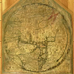
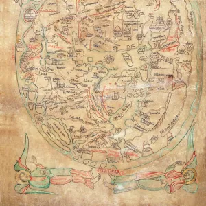
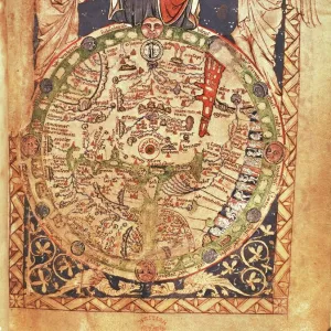
Photographic Print : Mappa Mundi, ink and colors on parchment, created in London about 1265


![]()
Photo Prints from Universal Images Group (UIG)
Mappa Mundi, ink and colors on parchment, created in London about 1265
Cartography, 13th century. Mappa Mundi, Medieval map, London about 1265. Ink and colors on parchment. The maps diameter is 9 cm
Universal Images Group (UIG) manages distribution for many leading specialist agencies worldwide
Media ID 9501673
© DEA PICTURE LIBRARY
13th Century Angel Anthropomorphic Direction Globe Guidance Ink Drawing Looking At Camera Medieval Mixed Media Simplicity Western Script
10"x8" Photo Print
Discover the fascinating history of cartography with our exquisite Media Storehouse Photographic Prints featuring the renowned Mappa Mundi. Created in London around 1265, this ancient masterpiece is a stunning representation of the medieval worldview. Intricately detailed with ink and colors on parchment, the Mappa Mundi map measures approximately 9 cm in diameter. This captivating print brings a piece of history into your home or office, transporting you back in time to the 13th century. Add this unique and thought-provoking addition to your collection and ignite your imagination. #MedievalMap #Cartography #History #MappaMundi #MedievalArt #Decor #UIG #MediaStorehousePrints
Photo prints are produced on Kodak professional photo paper resulting in timeless and breath-taking prints which are also ideal for framing. The colors produced are rich and vivid, with accurate blacks and pristine whites, resulting in prints that are truly timeless and magnificent. Whether you're looking to display your prints in your home, office, or gallery, our range of photographic prints are sure to impress. Dimensions refers to the size of the paper in inches.
Our Photo Prints are in a large range of sizes and are printed on Archival Quality Paper for excellent colour reproduction and longevity. They are ideal for framing (our Framed Prints use these) at a reasonable cost. Alternatives include cheaper Poster Prints and higher quality Fine Art Paper, the choice of which is largely dependant on your budget.
Estimated Product Size is 20.3cm x 25.4cm (8" x 10")
These are individually made so all sizes are approximate
Artwork printed orientated as per the preview above, with landscape (horizontal) or portrait (vertical) orientation to match the source image.
FEATURES IN THESE COLLECTIONS
> Arts
> Art Movements
> Medieval Art
> Arts
> Contemporary art
> Mixed media
> Paintings
> Arts
> Still life artwork
> Mixed media artworks
> Portraits
> Arts
> Portraits
> Mixed media artwork
> Arts
> Realistic drawings
> Portrait drawings
> Fine art
> Arts
> Street art graffiti
> Portrait paintings
> Mixed media artwork
> Europe
> United Kingdom
> England
> London
> Art
> Paintings
> Maps and Charts
> Related Images
> Popular Themes
> Maps and Charts
> Posters
> Scientific Posters
> Universal Images Group (UIG)
> Art
> Painting, Sculpture & Prints
> Illustration And Painting
EDITORS COMMENTS
This print showcases the remarkable "Mappa Mundi" a medieval map created in London around 1265. Crafted with ink and colors on parchment, this intricate piece of cartography measures approximately 9 cm in diameter. The portrait-style image captures the essence of this historical artifact, which serves as a testament to the ingenuity and artistry of its time. The Mappa Mundi is an awe-inspiring depiction of physical geography, offering insights into how people perceived the world during the 13th century. Its anthropomorphic elements, such as angelic figures and divine symbolism, add a touch of mystique to its overall design. This fine art painting draws inspiration from Byzantine style while incorporating Western script for labeling purposes. With no people present in the image, one can focus solely on admiring the intricacies within this masterpiece. The simplicity yet complexity of its design invites viewers to ponder upon its purpose: providing guidance for travelers or serving as a visual representation of history itself. As we gaze at this vertical composition, it feels as though we are looking directly into history's eyes. It reminds us that even centuries ago, humans sought direction and understanding through maps – seeking God's guidance in their journeys across uncharted territories
MADE IN THE USA
Safe Shipping with 30 Day Money Back Guarantee
FREE PERSONALISATION*
We are proud to offer a range of customisation features including Personalised Captions, Color Filters and Picture Zoom Tools
SECURE PAYMENTS
We happily accept a wide range of payment options so you can pay for the things you need in the way that is most convenient for you
* Options may vary by product and licensing agreement. Zoomed Pictures can be adjusted in the Cart.