Photographic Print > Arts > Artists > M > Sebastian Munster
Photographic Print : Map of Palestine, 1588


![]()
Photo Prints from Science Photo Library
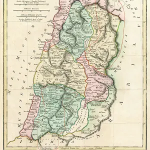
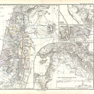
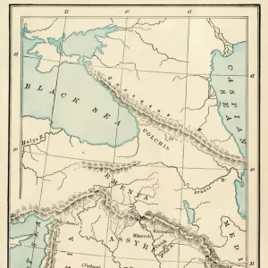
Map of Palestine, 1588
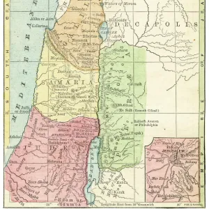
16th century map of Palestine. North is towards upper right. Published in 1588, this German map shows the geography of Palestine, centred on the area that later become the state of Israel. The inscriptions are in German, and the place names are in Latin. These include ancient names like Petra, Coele Syria and Judea. The Dead Sea is at lower centre, and the Mediterranean coast is at left. Numerous towns and villages are shown on the map. The map is by the German cartographer Sebastian Munster (1489-1552), and was published in Basel in a posthumous edition of his Cosmographia, the earliest German atlas
Science Photo Library features Science and Medical images including photos and illustrations
Media ID 1699831
© LIBRARY OF CONGRESS, GEOGRAPHY AND MAP DIVISION/SCIENCE PHOTO LIBRARY
1500s 1588 16th Century Arab Cartography Dead Sea German Israel Jewish Judea Medieval Middle Ages Middle East Palestine Cosmographia Petra Sebastian Munster
10"x8" Photo Print
Introducing the captivating "Map of Palestine, 1588" from our Media Storehouse range of Photographic Prints. This exquisite antique map, published in 1588, offers a fascinating glimpse into the geography of Palestine during the 16th century. Originating from Germany, this detailed representation of the region is centred on what would later become the modern-day state of Israel. With north indicated towards the upper right, this captivating piece of history is an essential addition to any space that values historical context and world exploration. Bring the rich history of Palestine into your home or office with the "Map of Palestine, 1588" Photographic Print from Media Storehouse.
Photo prints are produced on Kodak professional photo paper resulting in timeless and breath-taking prints which are also ideal for framing. The colors produced are rich and vivid, with accurate blacks and pristine whites, resulting in prints that are truly timeless and magnificent. Whether you're looking to display your prints in your home, office, or gallery, our range of photographic prints are sure to impress. Dimensions refers to the size of the paper in inches.
Our Photo Prints are in a large range of sizes and are printed on Archival Quality Paper for excellent colour reproduction and longevity. They are ideal for framing (our Framed Prints use these) at a reasonable cost. Alternatives include cheaper Poster Prints and higher quality Fine Art Paper, the choice of which is largely dependant on your budget.
Estimated Product Size is 25.4cm x 20.3cm (10" x 8")
These are individually made so all sizes are approximate
Artwork printed orientated as per the preview above, with landscape (horizontal) orientation to match the source image.
FEATURES IN THESE COLLECTIONS
> Arts
> Art Movements
> Medieval Art
> Arts
> Artists
> M
> Sebastian Munster
> Arts
> Artists
> S
> Syrian Syrian
> Asia
> Israel
> Related Images
> Asia
> Palestine
> Related Images
> Asia
> Syria
> Related Images
> Science Photo Library
> History
EDITORS COMMENTS
This 16th-century map of Palestine, printed in 1588, offers a fascinating glimpse into the geography and history of the region. Created by renowned German cartographer Sebastian Munster, this map showcases the area that would later become the state of Israel. With its north oriented towards the upper right corner, it presents an array of ancient names like Petra, Coele Syria, and Judea. The inscriptions on this print are in German while the place names are written in Latin. The Dead Sea takes center stage at the lower part of the map, while to its left lies the picturesque Mediterranean coast. This meticulously detailed artwork also highlights numerous towns and villages scattered across Palestine. Published posthumously as part of Munster's Cosmographia atlas in Basel, Switzerland, this historic piece provides invaluable insights into medieval cartography during a time when accurate maps were scarce. It serves as a testament to Munster's expertise and dedication to his craft. As we explore this remarkable snapshot from centuries past, we can appreciate both its artistic beauty and historical significance. From its depiction of ancient landmarks to its portrayal of regional boundaries long before modern political divisions emerged – this print is not only a treasure for geographers but also for those intrigued by Middle Eastern history and culture.
MADE IN THE USA
Safe Shipping with 30 Day Money Back Guarantee
FREE PERSONALISATION*
We are proud to offer a range of customisation features including Personalised Captions, Color Filters and Picture Zoom Tools
SECURE PAYMENTS
We happily accept a wide range of payment options so you can pay for the things you need in the way that is most convenient for you
* Options may vary by product and licensing agreement. Zoomed Pictures can be adjusted in the Cart.