Photographic Print > Europe > France > Maps
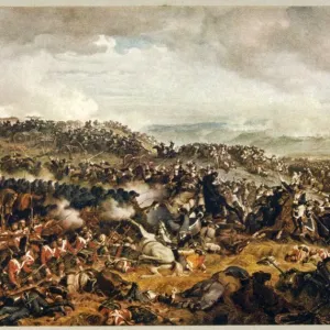
Photographic Print : Europe in 1810


![]()
Photo Prints from North Wind
Europe in 1810
Map of Europe in 1810, during the Napoleonic Wars (in German).
Printed color lithograph reproduction of a 19th-century illustration
North Wind Picture Archives brings history to life with stock images and hand-colored illustrations
Media ID 5882173
© North Wind Picture Archives
Europe European French Empire Napoleonic Wars 1810
10"x8" Photo Print
Discover the past with our exquisite Media Storehouse Photographic Prints featuring "Europe in 1810" from North Wind Picture Archives. This captivating print transports you back in time during the Napoleonic Wars, showcasing an intricately detailed map of Europe in 1810. The 19th-century illustration has been meticulously reproduced using color lithography, bringing the historical accuracy and vibrancy of the original to your home or office. Immerse yourself in the rich history of Europe's past and add a touch of sophistication to your space with this stunning, museum-quality print.
Photo prints are produced on Kodak professional photo paper resulting in timeless and breath-taking prints which are also ideal for framing. The colors produced are rich and vivid, with accurate blacks and pristine whites, resulting in prints that are truly timeless and magnificent. Whether you're looking to display your prints in your home, office, or gallery, our range of photographic prints are sure to impress. Dimensions refers to the size of the paper in inches.
Our Photo Prints are in a large range of sizes and are printed on Archival Quality Paper for excellent colour reproduction and longevity. They are ideal for framing (our Framed Prints use these) at a reasonable cost. Alternatives include cheaper Poster Prints and higher quality Fine Art Paper, the choice of which is largely dependant on your budget.
Estimated Product Size is 25.4cm x 20.3cm (10" x 8")
These are individually made so all sizes are approximate
Artwork printed orientated as per the preview above, with landscape (horizontal) orientation to match the source image.
FEATURES IN THESE COLLECTIONS
> North Wind Picture Archives
> Maps
> Maps and Charts
> Related Images
EDITORS COMMENTS
This vintage print takes us back to the year 1810, amidst the tumultuous era of the Napoleonic Wars. A true testament to European heritage and history, this beautifully illustrated map showcases the continent's political landscape during a time when empires clashed and borders shifted. With its intricate details and vibrant colors, it offers a glimpse into an epoch that shaped Europe as we know it today. The artistry of this 19th-century lithograph reproduction is truly remarkable. Each stroke captures the essence of traditional illustration techniques, transporting us to a bygone era where maps were not just practical tools but works of art in their own right. The delicate hues bring life to every region depicted on this historic map, allowing us to visualize how nations like France, Britain, Austria-Hungary, and Prussia once stood side by side. As we explore this piece further, one cannot help but be reminded of Napoleon Bonaparte's ambitious French Empire dominating much of Europe at that time. This print serves as a visual reminder of his far-reaching influence and military prowess during those turbulent years. Whether you are an avid history enthusiast or simply appreciate fine art from centuries past, this exquisite print will undoubtedly transport you back in time. It stands as a testament to Europe's rich cultural tapestry while offering an intriguing window into one of its most significant chapters – the Napoleonic Wars in all their glory and complexity.
MADE IN THE USA
Safe Shipping with 30 Day Money Back Guarantee
FREE PERSONALISATION*
We are proud to offer a range of customisation features including Personalised Captions, Color Filters and Picture Zoom Tools
SECURE PAYMENTS
We happily accept a wide range of payment options so you can pay for the things you need in the way that is most convenient for you
* Options may vary by product and licensing agreement. Zoomed Pictures can be adjusted in the Cart.