Photographic Print > Europe > France > Maps
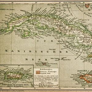
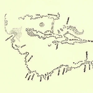
Photographic Print : CARIBBEAN MAP. A map of the Caribbean islands: woodcut, French, c. 1688


![]()
Photo Prints from Granger
CARIBBEAN MAP. A map of the Caribbean islands: woodcut, French, c. 1688
Granger holds millions of images spanning more than 25,000 years of world history, from before the Stone Age to the dawn of the Space Age
Media ID 7514139
1688 Caribbean Island New World West Indian Wood Cut
10"x8" Photo Print
Discover the rich history and beauty of the Caribbean with our exquisite range of Photographic Prints from Media Storehouse. This captivating piece features a vintage map of the Caribbean islands, dated back to around 1688. The map, sourced from The Granger Collection through Granger Art on Demand, is an intricately detailed woodcut creation of French origin. This antique map not only provides a glimpse into the past but also showcases the stunning islands of the Caribbean in a unique and historical light. Add this remarkable work of art to your collection and bring a touch of history and charm to your home or office.
Photo prints are produced on Kodak professional photo paper resulting in timeless and breath-taking prints which are also ideal for framing. The colors produced are rich and vivid, with accurate blacks and pristine whites, resulting in prints that are truly timeless and magnificent. Whether you're looking to display your prints in your home, office, or gallery, our range of photographic prints are sure to impress. Dimensions refers to the size of the paper in inches.
Our Photo Prints are in a large range of sizes and are printed on Archival Quality Paper for excellent colour reproduction and longevity. They are ideal for framing (our Framed Prints use these) at a reasonable cost. Alternatives include cheaper Poster Prints and higher quality Fine Art Paper, the choice of which is largely dependant on your budget.
Estimated Image Size (if not cropped) is 18.1cm x 25.4cm (7.1" x 10")
Estimated Product Size is 20.3cm x 25.4cm (8" x 10")
These are individually made so all sizes are approximate
Artwork printed orientated as per the preview above, with portrait (vertical) orientation to match the source image.
FEATURES IN THESE COLLECTIONS
> Granger Art on Demand
> Maps
> Maps and Charts
> Related Images
> Maps and Charts
> World
EDITORS COMMENTS
This print showcases a remarkable piece of history - a woodcut map of the Caribbean islands, crafted by French artisans around 1688. The intricate details and delicate engravings on this map transport us back to an era when exploration and colonization were shaping the New World. The map itself is a testament to the skill and artistry of its creators. Every island in the Caribbean archipelago is meticulously depicted, with their unique shapes and sizes accurately portrayed. The French influence is evident in the elegant design elements that adorn the edges of the map, adding a touch of sophistication to this historical artifact. As we gaze upon this vintage treasure, we are reminded of the rich cultural tapestry that defines these islands. From Cuba to Barbados, each landmass represented on this map has its own distinct identity and story waiting to be discovered. Beyond its aesthetic appeal, this woodcut serves as a window into our past. It offers valuable insights into how Europeans perceived and navigated through these uncharted waters centuries ago. It reminds us of the bravery and ambition that drove explorers like Christopher Columbus to venture into unknown territories. In acquiring this print from Granger Art on Demand, we not only bring home a beautiful piece for our collection but also pay homage to those who paved the way for our understanding of geography and history in one corner of our vast world - The Caribbean Islands.
MADE IN THE USA
Safe Shipping with 30 Day Money Back Guarantee
FREE PERSONALISATION*
We are proud to offer a range of customisation features including Personalised Captions, Color Filters and Picture Zoom Tools
SECURE PAYMENTS
We happily accept a wide range of payment options so you can pay for the things you need in the way that is most convenient for you
* Options may vary by product and licensing agreement. Zoomed Pictures can be adjusted in the Cart.