Photo Mug > Europe > United Kingdom > England > Surrey > Dorking
Photo Mug : Ordnance Survey map cover - Dorking and Leith Hill


![]()
Home Decor from Mary Evans Picture Library
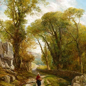
Ordnance Survey map cover - Dorking and Leith Hill
Front cover of an Ordnance Survey map covering the Dorking and Leith Hill area of Surrey. The cover features a hiker or rambler leaning against a wall and smoking a pipe as he consults his map. Cyclists and motoring day trippers can also be seen, along with a charming roadside inn. Date: c.1925
Mary Evans Picture Library makes available wonderful images created for people to enjoy over the centuries
Media ID 7165685
© Mary Evans Picture Library 2015 - https://copyrighthub.org/s0/hub1/creation/maryevans/MaryEvansPictureID/10504968
Country Side Hike Hiker Hikers Hiking Idyllic Peace Peaceful Ramblers Rambling Ruck Sack Sight Seeing Walker Walkers
Large Photo Mug (15 oz)
Introducing the Media Storehouse Photo Mug, a perfect blend of functionality and personalization. This mug features an stunning image of an Ordnance Survey map cover - Dorking and Leith Hill. The front cover of this vintage map showcases the picturesque Surrey countryside with a rambler in traditional attire, leaning against a wall and thoughtfully consulting his map. Each sip from this mug brings a touch of the great outdoors right to your desk. Our high-quality Photo Mugs are microwave and dishwasher safe, ensuring your morning brew or afternoon tea is always served in style. Add a personal touch to your day with this unique and captivating mug from Media Storehouse.
Elevate your coffee or tea experience with our premium white ceramic mug. Its wide, comfortable handle makes drinking easy, and you can rely on it to be both microwave and dishwasher safe. Sold in single units, preview may show both sides of the same mug so you can see how the picture wraps around.
Elevate your coffee or tea experience with our premium white ceramic mug. Its wide, comfortable handle makes drinking easy, and you can rely on it to be both microwave and dishwasher safe. Sold in single units, preview may show both sides of the same mug so you can see how the picture wraps around.
These are individually made so all sizes are approximate
FEATURES IN THESE COLLECTIONS
> Arts
> Artists
> E
> Walker Evans
> Europe
> United Kingdom
> England
> Maps
> Europe
> United Kingdom
> England
> Posters
> Europe
> United Kingdom
> England
> Related Images
> Europe
> United Kingdom
> England
> Surrey
> Dorking
> Europe
> United Kingdom
> England
> Surrey
> Related Images
> Maps and Charts
> Related Images
EDITORS COMMENTS
Step into the idyllic English countryside of the 1920s and 30s with this Ordnance Survey map cover featuring the Dorking and Leith Hill area of Surrey. The scene portrays a peaceful and serene atmosphere, with a hiker or rambler taking a leisurely break against a stone wall, pipe in hand and map spread out before him. His rucksack lies at his feet, indicating a longer hike through the picturesque countryside. Surrounding the scene, cyclists and motoring day trippers make their way along the winding roads, adding a sense of activity and exploration to the image. In the distance, a charming roadside inn beckons, inviting weary travelers to rest and refuel. The Ordnance Survey map, a trusted companion for explorers and adventurers, is a testament to the popularity of the great outdoors during this era. The map's cover, with its intricate detail and vibrant colors, transports us back in time to an age of peace and tranquility. This image, dated circa 1925, captures the essence of a bygone era, when the simple pleasures of a countryside hike or a leisurely cycle through the rolling hills were the height of holiday excitement. Whether you're a history buff, a nature lover, or simply someone who appreciates the beauty of the past, this Ordnance Survey map cover is a must-see for anyone seeking a glimpse into the peaceful and idyllic world of rural England during the 1920s and 30s.
MADE IN THE USA
Safe Shipping with 30 Day Money Back Guarantee
FREE PERSONALISATION*
We are proud to offer a range of customisation features including Personalised Captions, Color Filters and Picture Zoom Tools
SECURE PAYMENTS
We happily accept a wide range of payment options so you can pay for the things you need in the way that is most convenient for you
* Options may vary by product and licensing agreement. Zoomed Pictures can be adjusted in the Cart.