Photo Mug > Europe > France > Paris > Maps
Photo Mug : Map / Europe / France / Paris


![]()
Home Decor from Mary Evans Picture Library
Map / Europe / France / Paris
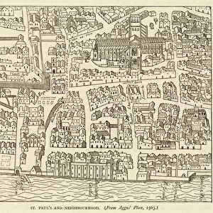
Map showing the growth of Paris from its earliest origins to the latest projects under Napoleon III
Mary Evans Picture Library makes available wonderful images created for people to enjoy over the centuries
Media ID 594576
© Mary Evans Picture Library 2015 - https://copyrighthub.org/s0/hub1/creation/maryevans/MaryEvansPictureID/10046917
1860 Earliest Growth I Ii Latest Maps Napoleon Origins Projects
Large Photo Mug (15 oz)
Introducing the Media Storehouse Photo Mug, a perfect blend of functionality and style. Featuring an exquisite image from Mary Evans Picture Library, this mug showcases a captivating map of Paris, France. Travel back in time as you sip your favorite beverage and explore the growth of Paris from its earliest origins to the latest projects under Napoleon III. Each mug in the Media Storehouse range is printed with high-quality, vibrant images that bring your favorite designs to life. Whether it's for yourself or as a thoughtful gift, this Parisian-inspired mug is sure to add a touch of charm to your daily routine.
Elevate your coffee or tea experience with our premium white ceramic mug. Its wide, comfortable handle makes drinking easy, and you can rely on it to be both microwave and dishwasher safe. Sold in single units, preview may show both sides of the same mug so you can see how the picture wraps around.
Elevate your coffee or tea experience with our premium white ceramic mug. Its wide, comfortable handle makes drinking easy, and you can rely on it to be both microwave and dishwasher safe. Sold in single units, preview may show both sides of the same mug so you can see how the picture wraps around.
These are individually made so all sizes are approximate
FEATURES IN THESE COLLECTIONS
> Mary Evans Prints Online
> Maps
> Europe
> France
> Paris
> Maps
> Europe
> France
> Paris
> Related Images
> Europe
> Related Images
> Maps and Charts
> Early Maps
> Maps and Charts
> Related Images
EDITORS COMMENTS
This print from Mary Evans Picture Library showcases a detailed map of Europe, specifically focusing on the growth of Paris throughout history. From its earliest origins to the latest projects under Napoleon III in 1860, this map provides a fascinating glimpse into the historical development of one of the most iconic cities in France.
The intricate details and markings on the map offer insight into how Paris evolved over time, highlighting key landmarks and significant changes that took place under Napoleon I and II. The viewer can trace the city's expansion and transformation through various eras, gaining a deeper understanding of its rich history and cultural significance.
As we study this map, we are transported back in time to witness the evolution of Paris unfold before our eyes. It serves as a reminder of the city's resilience and adaptability, showcasing how it has continuously reinvented itself to become the vibrant metropolis we know today.
Whether you're a history buff or simply appreciate beautiful cartography, this print is sure to captivate your imagination and spark your curiosity about Paris' past. Dive into this visual journey through time with Mary Evans Prints Online and explore the fascinating story behind one of Europe's most beloved cities.
MADE IN THE USA
Safe Shipping with 30 Day Money Back Guarantee
FREE PERSONALISATION*
We are proud to offer a range of customisation features including Personalised Captions, Color Filters and Picture Zoom Tools
SECURE PAYMENTS
We happily accept a wide range of payment options so you can pay for the things you need in the way that is most convenient for you
* Options may vary by product and licensing agreement. Zoomed Pictures can be adjusted in the Cart.