Photo Mug : British India 1801


![]()
Home Decor from Mary Evans Picture Library
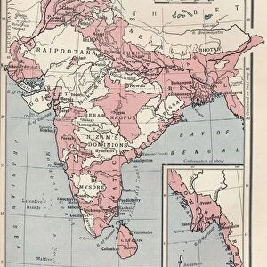
British India 1801
Map showing the expanision of the British Dominion in India Date: 1801
Mary Evans Picture Library makes available wonderful images created for people to enjoy over the centuries
Media ID 7154049
© Mary Evans Picture Library 2015 - https://copyrighthub.org/s0/hub1/creation/maryevans/MaryEvansPictureID/10149966
Large Photo Mug (15 oz)
"Bring history to your morning routine with our Media Storehouse Photo Mugs. This unique mug showcases an intriguing map of "British India 1801" from Mary Evans Prints Online. Witness the expansion of the British Dominion in India as you enjoy your favorite beverage. Each mug is expertly printed with high-quality, vibrant images that are sure to start your day off right. Order yours today and drink to the past, present, or future - the choice is yours!"
Elevate your coffee or tea experience with our premium white ceramic mug. Its wide, comfortable handle makes drinking easy, and you can rely on it to be both microwave and dishwasher safe. Sold in single units, preview may show both sides of the same mug so you can see how the picture wraps around.
Elevate your coffee or tea experience with our premium white ceramic mug. Its wide, comfortable handle makes drinking easy, and you can rely on it to be both microwave and dishwasher safe. Sold in single units, preview may show both sides of the same mug so you can see how the picture wraps around.
These are individually made so all sizes are approximate
EDITORS COMMENTS
This map print, dated 1801, offers a fascinating glimpse into the expansion of the British Dominion in India during the colonial era. The map, sourced from Mary Evans Prints Online, meticulously charts the territorial gains made by the British East India Company and the British Crown in Asia over the preceding centuries. The map's intricate details reveal the vast expanse of British control in India, extending from the eastern coast, encompassing present-day West Bengal, Bihar, and Orissa, to the western coast, including Gujarat and the Malabar Coast. The British influence is also evident in the northern regions, where the territories of Punjab, Kashmir, and parts of present-day Uttar Pradesh and Bihar are shown under British control. The map serves as a testament to the strategic and diplomatic prowess of the British during this period. It illustrates how the British East India Company, which began as a trading entity, gradually transformed into a political power, securing territories through treaties, alliances, and military conquests. The map also underscores the significant impact of British rule on the Indian subcontinent, shaping its political, economic, and cultural landscape for generations to come. The intricate lines and borders on this map offer a visual representation of the complex history of British India, inviting us to explore the rich tapestry of colonial history and the enduring legacy of the British Empire in Asia.
MADE IN THE USA
Safe Shipping with 30 Day Money Back Guarantee
FREE PERSONALISATION*
We are proud to offer a range of customisation features including Personalised Captions, Color Filters and Picture Zoom Tools
FREE COLORIZATION SERVICE
You can choose advanced AI Colorization for this picture at no extra charge!
SECURE PAYMENTS
We happily accept a wide range of payment options so you can pay for the things you need in the way that is most convenient for you
* Options may vary by product and licensing agreement. Zoomed Pictures can be adjusted in the Cart.