Mouse Mat > Europe > Iceland > Maps
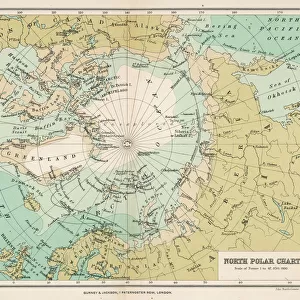
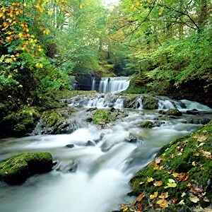
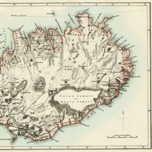
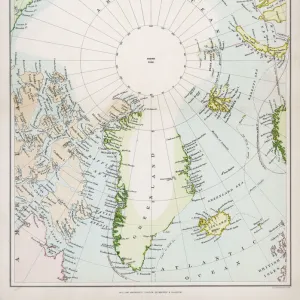
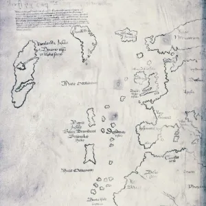
Mouse Mat : Map / Arctic Circle C1880

![]()
Home Decor from Mary Evans Picture Library
Map / Arctic Circle C1880
Map of the Arctic Circle with details of explorations
Mary Evans Picture Library makes available wonderful images created for people to enjoy over the centuries
Media ID 608858
© Mary Evans Picture Library 2015 - https://copyrighthub.org/s0/hub1/creation/maryevans/MaryEvansPictureID/10114193
Alaska Arctic C1880 Circle Explorations Greenland Iceland Maps Spitzbergen
Mouse Pad
Standard Size Mouse Pad 7.75" x 9..25". High density Neoprene w linen surface. Easy to clean, stain resistant finish. Rounded corners.
Archive quality photographic print in a durable wipe clean mouse mat with non slip backing. Works with all computer mice
Estimated Image Size (if not cropped) is 19.1cm x 23.7cm (7.5" x 9.3")
Estimated Product Size is 20.2cm x 23.7cm (8" x 9.3")
These are individually made so all sizes are approximate
Artwork printed orientated as per the preview above, with portrait (vertical) orientation to match the source image.
FEATURES IN THESE COLLECTIONS
> Europe
> Iceland
> Related Images
> Maps and Charts
> Early Maps
> Maps and Charts
> Related Images
> North America
> Greenland
> Maps
> North America
> Greenland
> Related Images
EDITORS COMMENTS
This stunning print captures a detailed map of the Arctic Circle circa 1880, showcasing the vast and icy expanse of this remote region. The map is filled with intricate details of explorations, highlighting key locations such as Iceland, Greenland, Alaska, and Spitzbergen. Each line and marking on the map tells a story of brave adventurers who ventured into the unknown in search of new lands and discoveries.
The cool tones of blue and green evoke a sense of coldness and isolation that is characteristic of the Arctic landscape. Looking at this historical map, one can't help but feel a sense of awe at the sheer magnitude and beauty of this untouched wilderness.
As we study each carefully drawn contour line and label on the map, we are transported back in time to an era when exploration was not just about conquering new territories, but also about pushing boundaries and expanding human knowledge. This piece serves as a reminder of our insatiable curiosity about the world around us and our relentless pursuit to uncover its secrets.
Mary Evans Picture Library has truly captured the essence of adventure and discovery in this remarkable photo print. It is a testament to human ingenuity and perseverance in the face of extreme challenges.
MADE IN THE USA
Safe Shipping with 30 Day Money Back Guarantee
FREE PERSONALISATION*
We are proud to offer a range of customisation features including Personalised Captions, Color Filters and Picture Zoom Tools
SECURE PAYMENTS
We happily accept a wide range of payment options so you can pay for the things you need in the way that is most convenient for you
* Options may vary by product and licensing agreement. Zoomed Pictures can be adjusted in the Cart.