Metal Print > Arts > Artists > M > Gerardus Mercator
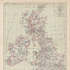
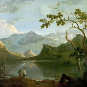
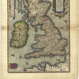
Metal Print : 16th century map of the British Isles


![]()
Metal Prints from Science Photo Library
16th century map of the British Isles
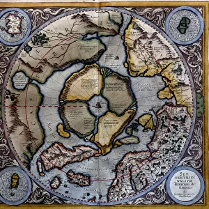
British Isles, 16th century Dutch map. This shows England, Scotland, Wales and Ireland, though Ireland is not yet accurately mapped. Published in 1595, from work by Gerard Mercator
Science Photo Library features Science and Medical images including photos and illustrations
Media ID 6348667
© GEORGETTE DOUWMA/SCIENCE PHOTO LIBRARY
16th Century Ancient British Isles Cartography Distorted Distortion Dutch Earth Science Illustrated Inaccurate Incomplete Ireland Irish Latin Mapping Maps Mercator Sciences Scot Land Scottish Sixteenth Wales Welsh 1593 1595 Gerard Gerardus
16"x20" (51x41cm) Metal Print
Discover history like never before with Media Storehouse's Metal Prints. This captivating piece features a rare 16th century map of the British Isles, published by Gerard Mercator in 1595. Witness the intricate details of this Dutch map, which beautifully depicts England, Scotland, and Wales, along with an early representation of Ireland. Bring the rich history of this era into your home or office with our high-quality Metal Prints, which showcase vibrant colors and sharp details on a durable, sleek metal surface. Perfect for history enthusiasts and collectors, this unique and stylish decor piece is sure to be a conversation starter.
Made with durable metal and luxurious printing techniques, our metal photo prints go beyond traditional canvases, adding a cool, modern touch to your space. Wall mount on back. Eco-friendly 100% post-consumer recycled ChromaLuxe aluminum surface. The thickness of the print is 0.045". Featuring a Scratch-resistant surface and Rounded corners. Backing hangers are attached to the back of the print and float the print 1/2-inch off the wall when hung, the choice of hanger may vary depending on size and International orders will come with Float Mount hangers only. Finished with a brilliant white high gloss surface for unsurpassed detail and vibrance. Printed using Dye-Sublimation and for best care we recommend a non-ammonia glass cleaner, water, or isopropyl (rubbing) alcohol to prevent harming the print surface. We recommend using a clean, lint-free cloth to wipe off the print. The ultra-hard surface is scratch-resistant, waterproof and weatherproof. Avoid direct sunlight exposure.
Made with durable metal and luxurious printing techniques, metal prints bring images to life and add a modern touch to any space
Estimated Image Size (if not cropped) is 50.8cm x 40.6cm (20" x 16")
Estimated Product Size is 51.4cm x 41.2cm (20.2" x 16.2")
These are individually made so all sizes are approximate
Artwork printed orientated as per the preview above, with landscape (horizontal) orientation to match the source image.
FEATURES IN THESE COLLECTIONS
> Arts
> Artists
> M
> Gerardus Mercator
> Europe
> France
> Canton
> Landes
> Europe
> Republic of Ireland
> Maps
> Europe
> United Kingdom
> England
> Maps
> Europe
> United Kingdom
> Maps
> Europe
> United Kingdom
> Related Images
> Europe
> United Kingdom
> Scotland
> Maps
> Europe
> United Kingdom
> Scotland
> Posters
> Europe
> United Kingdom
> Scotland
> Related Images
> Europe
> United Kingdom
> Wales
> Maps
> Maps and Charts
> Gerardus Mercator's Cartographic
EDITORS COMMENTS
This 16th-century Dutch map of the British Isles takes us on a historical journey through time. Created by Gerard Mercator and published in 1595, this intricate piece of cartography showcases England, Scotland, Wales, and Ireland, although the accuracy of the latter is yet to be fully realized. The artistry displayed in this illustration is truly remarkable. Every stroke and detail transports us back to an era when maps were not only navigational tools but also works of art. The distortion present in this map adds a unique charm, reminding us that geographical knowledge was still evolving during this period. As we explore every inch of this ancient treasure, it becomes evident that its purpose extended beyond mere geography. It serves as a testament to the rich history and cultural diversity found within these lands. From the Dutch influence evident in its creation to the Latin inscriptions scattered throughout, each element tells a story waiting to be discovered. While some may view its inaccuracies as shortcomings today, they serve as reminders of how far our understanding has come since then. This print allows us to appreciate both the progress made by modern sciences such as earth science and cartography while honoring those who laid the foundations for our current knowledge. In preserving this snapshot from centuries past, Science Photo Library invites us all to delve into an enchanting world where old meets new—a world where exploration knows no bounds.
MADE IN THE USA
Safe Shipping with 30 Day Money Back Guarantee
FREE PERSONALISATION*
We are proud to offer a range of customisation features including Personalised Captions, Color Filters and Picture Zoom Tools
SECURE PAYMENTS
We happily accept a wide range of payment options so you can pay for the things you need in the way that is most convenient for you
* Options may vary by product and licensing agreement. Zoomed Pictures can be adjusted in the Cart.