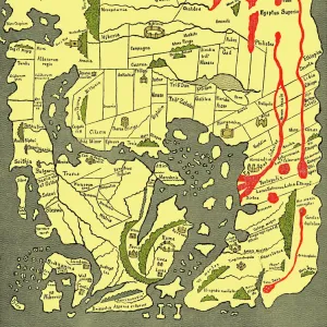
Metal Print : RAF navigators map of Frankfurt


![]()
Metal Prints from Mary Evans Picture Library
RAF navigators map of Frankfurt
Ordance survey map of Germany around Frankfurt, showing the location of Cologne (Koln), Koblenz, Frankfurt and other towns and cities in the area, compiled and drawn at the War Office. The map was used by RAF navigators on bombing raids
Mary Evans Picture Library makes available wonderful images created for people to enjoy over the centuries
Media ID 4478665
© Mary Evans Picture Library 2015 - https://copyrighthub.org/s0/hub1/creation/maryevans/MaryEvansPictureID/10439027
1942 Bombers Bombing Cologne Frankfurt Koblenz Koln Maps Navigator Navigators Raid Raids Survey Ww 2 Ww Ii Bomber
16"x20" (51x41cm) Metal Print
Discover the rich history of aviation with our stunning Metal Prints featuring an Ordance Survey map of Germany around Frankfurt. This unique piece showcases the location of key cities such as Cologne (Koln) and Koblenz, as well as Frankfurt, during a pivotal time in history. Meticulously compiled and drawn at the War Office, this Rights Managed image from Mary Evans Prints Online brings a touch of vintage charm and intrigue to any space. Our high-quality Metal Prints are not only visually appealing but also durable and long-lasting, making them an excellent addition to your home or office décor. Elevate your interior design with this captivating and historically significant map.
Made with durable metal and luxurious printing techniques, our metal photo prints go beyond traditional canvases, adding a cool, modern touch to your space. Wall mount on back. Eco-friendly 100% post-consumer recycled ChromaLuxe aluminum surface. The thickness of the print is 0.045". Featuring a Scratch-resistant surface and Rounded corners. Backing hangers are attached to the back of the print and float the print 1/2-inch off the wall when hung, the choice of hanger may vary depending on size and International orders will come with Float Mount hangers only. Finished with a brilliant white high gloss surface for unsurpassed detail and vibrance. Printed using Dye-Sublimation and for best care we recommend a non-ammonia glass cleaner, water, or isopropyl (rubbing) alcohol to prevent harming the print surface. We recommend using a clean, lint-free cloth to wipe off the print. The ultra-hard surface is scratch-resistant, waterproof and weatherproof. Avoid direct sunlight exposure.
Made with durable metal and luxurious printing techniques, metal prints bring images to life and add a modern touch to any space
Estimated Image Size (if not cropped) is 50.8cm x 40.6cm (20" x 16")
Estimated Product Size is 51.4cm x 41.2cm (20.2" x 16.2")
These are individually made so all sizes are approximate
Artwork printed orientated as per the preview above, with landscape (horizontal) orientation to match the source image.
EDITORS COMMENTS
This historic photograph depicts an Ordnance Survey map of the Frankfurt region in Germany, compiled and drawn at the War Office during World War II. The map, which dates back to 1942, provides a detailed and intricate representation of the area surrounding Frankfurt, including the locations of Cologne (Koln) and Koblenz. During the intense aerial campaigns of World War II, RAF navigators relied on maps like this one to guide their bombing raids over enemy territory. The map's precise and meticulous details would have been essential for navigators as they planned their routes and targeted specific areas with bombs. The map's title, "Frankfurt on the Main and Surrounding Areas," is written in bold letters at the top, with a scale of 1:250,000 and the year of publication, 1942, noted at the bottom. The map's intricate details include roads, railways, bodies of water, and the locations of towns and cities, all rendered in crisp, clear lines. The map's historical significance is underscored by the context of its creation. The RAF's bombing campaigns during World War II were a pivotal part of the Allied effort to weaken the German war machine and ultimately bring about its defeat. Navigators like those who used this map played a crucial role in these campaigns, risking their lives to deliver bombs to their targets with precision and accuracy. This photograph is a poignant reminder of the vital role that maps played in the history of military aviation and the strategic planning of bombing raids during World War II. The intricate details of this Ordnance Survey map of Frankfurt and its surrounding areas offer a glimpse into the meticulous planning and execution of these historic military operations.
MADE IN THE USA
Safe Shipping with 30 Day Money Back Guarantee
FREE PERSONALISATION*
We are proud to offer a range of customisation features including Personalised Captions, Color Filters and Picture Zoom Tools
SECURE PAYMENTS
We happily accept a wide range of payment options so you can pay for the things you need in the way that is most convenient for you
* Options may vary by product and licensing agreement. Zoomed Pictures can be adjusted in the Cart.