Jigsaw Puzzle > Europe > United Kingdom > England > London > Museums > London Canal Museum
Jigsaw Puzzle : First geological map of Britain, 1815 C016 / 5681


![]()
Jigsaw Puzzles from Science Photo Library
First geological map of Britain, 1815 C016 / 5681
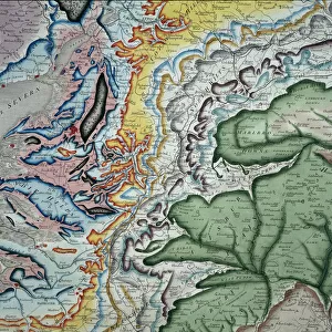
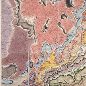
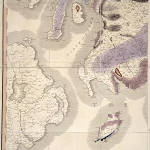
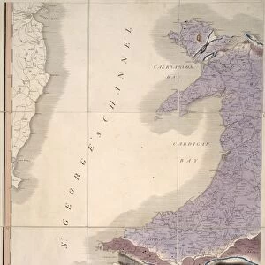
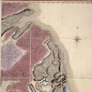
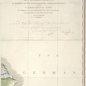
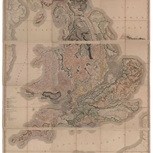
First geological map of Britain, detail of the South East of England (figure 6). This map was published in 1815 by British geologist William Smith (1769-1839). It shows rock layers (strata) in England and Wales and part of Scotland (key at lower left). Smiths work as a canal surveyor allowed him to study geology. He discovered that geological strata could be reliably identified at different places on the basis of the fossils they contained. Smith also proposed the principle of superposition, that if a strata overlays another then it was laid down at a later time. He is considered the father of English geology
Science Photo Library features Science and Medical images including photos and illustrations
Media ID 9206567
© NATURAL HISTORY MUSEUM, LONDON/SCIENCE PHOTO LIBRARY
1815 Cartography Country Earth Science English Channel Geological Great Britain Pioneering Region Scottish South East Strata Stratigraphy Stratum Superposition Welsh William Smith South Downs
Jigsaw Puzzle (1014 Pieces)
Discover the rich history of geology with our captivating jigsaw puzzle from Media Storehouse. This intricately designed puzzle features a piece of scientific history - the First Geological Map of Britain, published in 1815 by the renowned British geologist, William Smith. The detailed image showcases a section of the South East of England, brought to life through the Natural History Museum, London/Science Photo Library's captivating archives. Engage in a stimulating puzzle experience while immersing yourself in the world of geology and the fascinating story of its early exploration. Perfect for enthusiasts, educators, and anyone seeking a challenging and rewarding pastime.
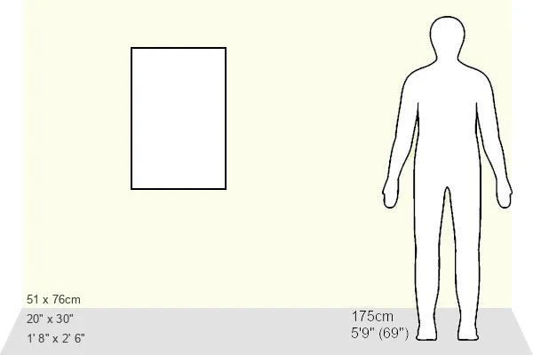
Made in the USA, 1014-piece puzzles measure 20" x 30" (50.8 x 76.2 cm). Every puzzle is meticulously printed on glossy photo paper, which has a strong 1.33 mm thickness. Delivered in a black storage cardboard box, these puzzles are both stylish and practical. (Note: puzzles contain small parts and are not suitable for children under 3 years of age.)
Jigsaw Puzzles are an ideal gift for any occasion
Estimated Product Size is 50.8cm x 76cm (20" x 29.9")
These are individually made so all sizes are approximate
Artwork printed orientated as per the preview above, with portrait (vertical) orientation to match the source image.
FEATURES IN THESE COLLECTIONS
> Asia
> East Timor
> Maps
> Asia
> East Timor
> Related Images
> Europe
> United Kingdom
> England
> London
> Museums
> British Library
> Europe
> United Kingdom
> England
> London
> Museums
> British Museum
> Europe
> United Kingdom
> England
> London
> Museums
> London Canal Museum
> Europe
> United Kingdom
> England
> London
> Museums
> Natural History Museum
> Europe
> United Kingdom
> England
> London
> Museums
> Science Museum
> Europe
> United Kingdom
> England
> London
> Sights
> British Museum
> Europe
> United Kingdom
> England
> London
> Sights
> London Canal Museum
> Europe
> United Kingdom
> England
> London
> Towns
> Lower Place
EDITORS COMMENTS
This print showcases the first geological map of Britain, a groundbreaking work published in 1815 by British geologist William Smith. The map, which is a detailed depiction of the South East of England (figure 6), offers a glimpse into the rich history and geological composition of this region. William Smith's remarkable contribution to geology stemmed from his career as a canal surveyor, allowing him to closely study the Earth's strata. Through meticulous observations, he discovered that different rock layers could be reliably identified based on the fossils they contained. This revolutionary insight laid the foundation for stratigraphy and established Smith as the father of English geology. The map itself provides an intricate illustration of England and Wales, along with parts of Scotland. It includes key information about various rock layers or strata found across these regions, offering valuable insights into their geological makeup. Smith also proposed the principle of superposition, suggesting that if one layer overlays another, it was deposited at a later time. This concept revolutionized our understanding of Earth's history and continues to shape modern geological studies. As we delve into this historical masterpiece created almost two centuries ago, we are reminded not only of its pioneering significance but also its artistic beauty. The intricate cartography captures both scientific accuracy and aesthetic appeal—a testament to William Smith's genius as well as his dedication to unraveling Earth's mysteries through artistry and science combined.
MADE IN THE USA
Safe Shipping with 30 Day Money Back Guarantee
FREE PERSONALISATION*
We are proud to offer a range of customisation features including Personalised Captions, Color Filters and Picture Zoom Tools
SECURE PAYMENTS
We happily accept a wide range of payment options so you can pay for the things you need in the way that is most convenient for you
* Options may vary by product and licensing agreement. Zoomed Pictures can be adjusted in the Cart.