Jigsaw Puzzle > Arts > Artists > C > Juan de la Cosa
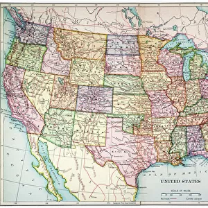
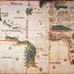
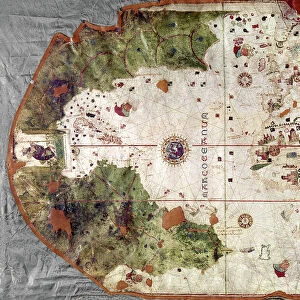
Jigsaw Puzzle : NINA: WORLD MAP, 1500. World map, 1500, of Juan de la Cosa, navigator on the Nina on Christopher Columbus second voyage


![]()
Jigsaw Puzzles from Granger
NINA: WORLD MAP, 1500. World map, 1500, of Juan de la Cosa, navigator on the Nina on Christopher Columbus second voyage
NINA: WORLD MAP, 1500. World map, 1500, of Juan de la Cosa, navigator on the Nina on Christopher Columbus second voyage of 1493-94
Granger holds millions of images spanning more than 25,000 years of world history, from before the Stone Age to the dawn of the Space Age
Media ID 6622077
1500 Africa Age Of Discovery Asia Bradley Smith Caribbean Cartography Christopher Columbus Expedition Exploration Explorer Juan New World Nina Portolan Chart Spain Spanish World Cosa
Jigsaw Puzzle (1014 Pieces)
Discover the rich history of exploration with our intricately designed jigsaw puzzle from Media Storehouse. Featuring the captivating "Nina: World Map, 1500" by The Granger Collection, this puzzle presents a fascinating glimpse into the past. Depicting the world map created by Juan de la Cosa, a navigator on Christopher Columbus' second voyage, this puzzle invites you to piece together the intricate details of this historically significant chart. Immerse yourself in the adventure and satisfaction of solving this captivating puzzle, perfect for history enthusiasts and puzzle lovers alike.
Made in the USA, 1014-piece puzzles measure 20" x 30" (50.8 x 76.2 cm). Every puzzle is meticulously printed on glossy photo paper, which has a strong 1.33 mm thickness. Delivered in a black storage cardboard box, these puzzles are both stylish and practical. (Note: puzzles contain small parts and are not suitable for children under 3 years of age.)
Jigsaw Puzzles are an ideal gift for any occasion
Estimated Product Size is 76cm x 50.8cm (29.9" x 20")
These are individually made so all sizes are approximate
Artwork printed orientated as per the preview above, with landscape (horizontal) orientation to match the source image.
FEATURES IN THESE COLLECTIONS
> Granger Art on Demand
> Maps
> Africa
> Related Images
> Animals
> Mammals
> Soricidae
> Navigator
> Arts
> Art Movements
> Renaissance Art
> Arts
> Artists
> C
> Juan de la Cosa
> Asia
> Related Images
> Europe
> Spain
> Related Images
EDITORS COMMENTS
This print titled "NINA: WORLD MAP, 1500" takes us back to the early years of exploration and discovery. Created by Juan de la Cosa, a skilled navigator on Christopher Columbus' second voyage in 1493-94, this world map offers a glimpse into the Renaissance era of cartography. The intricate details showcased in this print highlight the ambition and curiosity that fueled expeditions during the Age of Discovery. As we study the map, we can trace Columbus' journey across the vast Atlantic Ocean towards uncharted territories. The Caribbean islands emerge as key landmarks, representing new lands encountered by European explorers. The artist's skillful rendering transports us to an era when maps were not only tools for navigation but also works of art. With delicate brushstrokes and precise attention to detail, Juan de la Cosa captures Africa's coastline extending eastward towards Asia while Spain proudly stands at its center. This remarkable piece from Bradley Smith's Carousel Collection invites us to reflect on humanity's insatiable thirst for knowledge and adventure. It serves as a reminder that it was through courageous individuals like Columbus and his crew aboard the Nina that our understanding of the world expanded exponentially. As we admire this historical artifact turned artwork, let us appreciate both its aesthetic beauty and its significance in shaping our collective history.
MADE IN THE USA
Safe Shipping with 30 Day Money Back Guarantee
FREE PERSONALISATION*
We are proud to offer a range of customisation features including Personalised Captions, Color Filters and Picture Zoom Tools
SECURE PAYMENTS
We happily accept a wide range of payment options so you can pay for the things you need in the way that is most convenient for you
* Options may vary by product and licensing agreement. Zoomed Pictures can be adjusted in the Cart.