Fine Art Print > Universal Images Group (UIG) > Illustrations > Illustrations 1
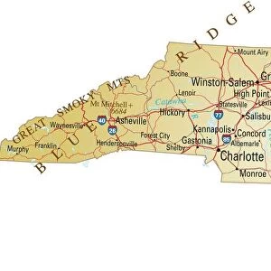
Fine Art Print : Map of North Carolina, close-up


![]()
Fine Art Prints from Universal Images Group (UIG)
Map of North Carolina, close-up
Universal Images Group (UIG) manages distribution for many leading specialist agencies worldwide
Media ID 9540099
© Dorling Kindersley/UIG
Digitally Generated Direction Guidance North Carolina State Text Us State Border Western Script
21"x14" (+3" Border) Fine Art Print
Discover the intricate details of North Carolina with our exquisite Fine Art Print from Dorling Kindersley at Media Storehouse. This captivating close-up view of the Map of North Carolina, brought to you by Universal Images Group (UIG), is a stunning addition to any home or office. With its rich colors and meticulous detail, this fine art print transports you to the heart of North Carolina, making it a perfect conversation starter and a beautiful decor piece. Bring history and geography to life with this exceptional work of art.
21x14 image printed on 27x20 Fine Art Rag Paper with 3" (76mm) white border. Our Fine Art Prints are printed on 300gsm 100% acid free, PH neutral paper with archival properties. This printing method is used by museums and art collections to exhibit photographs and art reproductions.
Our fine art prints are high-quality prints made using a paper called Photo Rag. This 100% cotton rag fibre paper is known for its exceptional image sharpness, rich colors, and high level of detail, making it a popular choice for professional photographers and artists. Photo rag paper is our clear recommendation for a fine art paper print. If you can afford to spend more on a higher quality paper, then Photo Rag is our clear recommendation for a fine art paper print.
Estimated Image Size (if not cropped) is 53.3cm x 27.9cm (21" x 11")
Estimated Product Size is 68.6cm x 50.8cm (27" x 20")
These are individually made so all sizes are approximate
Artwork printed orientated as per the preview above, with landscape (horizontal) orientation to match the source image.
EDITORS COMMENTS
This print showcases a close-up view of the Map of North Carolina, revealing the intricate details and rich geography of this diverse state. The map, expertly crafted by Dorling Kindersley, offers a comprehensive guide to navigating through the various regions and landmarks that define North Carolina's beauty. The vibrant colors used in this digitally generated illustration bring life to the map, highlighting its physical features with utmost clarity. From majestic mountain ranges to sprawling coastlines, every contour is meticulously depicted, inviting viewers on an imaginary journey across this remarkable state. With Western script labeling key cities and towns, as well as US state borders clearly demarcated, this visually stunning piece provides both aesthetic pleasure and practical guidance. Whether you're planning an adventure or simply exploring from afar, this map serves as a reliable companion for understanding North Carolina's topography. As we gaze upon this mesmerizing artwork captured by Universal Images Group (UIG), it becomes evident that there are no people present in the frame. Instead, our attention is solely focused on appreciating the artistry behind cartography and celebrating the natural wonders that make up North Carolina's landscape. This photograph print stands as a testament to Dorling Kindersley's dedication to creating informative yet visually appealing maps while also showcasing UIG's commitment to capturing breathtaking images that inspire exploration and appreciation for our world.
MADE IN THE USA
Safe Shipping with 30 Day Money Back Guarantee
FREE PERSONALISATION*
We are proud to offer a range of customisation features including Personalised Captions, Color Filters and Picture Zoom Tools
SECURE PAYMENTS
We happily accept a wide range of payment options so you can pay for the things you need in the way that is most convenient for you
* Options may vary by product and licensing agreement. Zoomed Pictures can be adjusted in the Cart.