Fine Art Print > Europe > United Kingdom > Wales > Maps
Fine Art Print : Map of England, 1800s


Fine Art Prints from North Wind
Map of England, 1800s
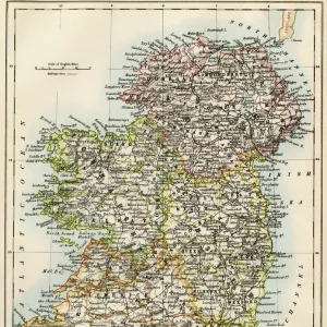
Map of England and Wales, 1870s.
Color lithograph reproduction of a 19th-century illustration
North Wind Picture Archives brings history to life with stock images and hand-colored illustrations
Media ID 5879148
© North Wind Picture Archives
1870s Britain British England English Europe European Great Britain Wales Counties
20"x16" (+3" Border) Fine Art Print
Step back in time with our exquisite Fine Art Print from Media Storehouse, featuring a captivating Map of England and Wales from the 1870s. This stunning reproduction, sourced from the North Wind Picture Archives, showcases the intricate details of a bygone era. The vibrant colors and meticulous lines of this color lithograph transport you to the heart of the 19th century, making it a perfect addition to any home or office space. Bring history to life with this beautiful and authentic work of art.
20x16 image printed on 26x22 Fine Art Rag Paper with 3" (76mm) white border. Our Fine Art Prints are printed on 300gsm 100% acid free, PH neutral paper with archival properties. This printing method is used by museums and art collections to exhibit photographs and art reproductions.
Our fine art prints are high-quality prints made using a paper called Photo Rag. This 100% cotton rag fibre paper is known for its exceptional image sharpness, rich colors, and high level of detail, making it a popular choice for professional photographers and artists. Photo rag paper is our clear recommendation for a fine art paper print. If you can afford to spend more on a higher quality paper, then Photo Rag is our clear recommendation for a fine art paper print.
Estimated Image Size (if not cropped) is 40.6cm x 50.8cm (16" x 20")
Estimated Product Size is 55.9cm x 66cm (22" x 26")
These are individually made so all sizes are approximate
Artwork printed orientated as per the preview above, with portrait (vertical) orientation to match the source image.
FEATURES IN THESE COLLECTIONS
> Europe
> United Kingdom
> England
> Maps
> Europe
> United Kingdom
> Maps
> Europe
> United Kingdom
> Wales
> Maps
> Europe
> United Kingdom
> Wales
> Posters
> Europe
> United Kingdom
> Wales
> Related Images
> Maps and Charts
> Related Images
> Maps and Charts
> Wales
> North Wind Picture Archives
> British history
> North Wind Picture Archives
> Maps
EDITORS COMMENTS
This stunning color lithograph reproduction takes us back to the 1800s, specifically the 1870s, with its intricate illustration of a Map of England and Wales. The vintage charm emanating from this print instantly transports us to an era filled with rich history and tradition. The map showcases the counties of England and Wales in exquisite detail, allowing us to explore the diverse landscapes that make up these regions. Each county is meticulously labeled, giving us a glimpse into their historical significance and cultural heritage. From bustling cities to picturesque countryside, this map encapsulates the essence of Great Britain during this period. As we delve deeper into this artwork, we can't help but appreciate the artistic flair that went into creating it. The skillful use of colors brings life to every corner of the map, making it visually captivating. It serves not only as a geographical reference but also as a work of art that celebrates British culture and identity. Whether you are an avid historian or simply captivated by European artistry, this Map of England and Wales from North Wind Picture Archives offers a window into the past like no other. Its presence on any wall would undoubtedly spark conversations about British history, geography, and even personal connections to these lands across generations.
MADE IN THE USA
Safe Shipping with 30 Day Money Back Guarantee
FREE PERSONALISATION*
We are proud to offer a range of customisation features including Personalised Captions, Color Filters and Picture Zoom Tools
SECURE PAYMENTS
We happily accept a wide range of payment options so you can pay for the things you need in the way that is most convenient for you
* Options may vary by product and licensing agreement. Zoomed Pictures can be adjusted in the Cart.