Fine Art Print > Maps and Charts > British Empire Maps
Fine Art Print : Map of the British Empire


Fine Art Prints from Mary Evans Picture Library
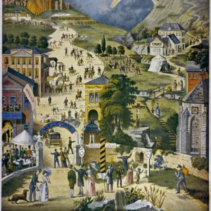
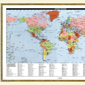
Map of the British Empire
The Howard Vincent map of the British Empire, 1897 Date: 1897
Mary Evans Picture Library makes available wonderful images created for people to enjoy over the centuries
Media ID 7403809
© Mary Evans Picture Library 2015 - https://copyrighthub.org/s0/hub1/creation/maryevans/MaryEvansPictureID/10474597
20"x16" (+3" Border) Fine Art Print
Discover the rich history of the British Empire with our exquisite Fine Art Prints from Media Storehouse. This captivating Map of the British Empire, created by Howard Vincent in 1897, showcases the extent of the British Empire at the height of its power. The intricate details and vibrant colors of this Rights Managed print from Mary Evans Prints Online bring history to life, making it a stunning addition to any home or office. Order now and transport yourself back in time, as you explore the fascinating story of the British Empire.
20x16 image printed on 26x22 Fine Art Rag Paper with 3" (76mm) white border. Our Fine Art Prints are printed on 300gsm 100% acid free, PH neutral paper with archival properties. This printing method is used by museums and art collections to exhibit photographs and art reproductions.
Our fine art prints are high-quality prints made using a paper called Photo Rag. This 100% cotton rag fibre paper is known for its exceptional image sharpness, rich colors, and high level of detail, making it a popular choice for professional photographers and artists. Photo rag paper is our clear recommendation for a fine art paper print. If you can afford to spend more on a higher quality paper, then Photo Rag is our clear recommendation for a fine art paper print.
Estimated Image Size (if not cropped) is 46.7cm x 40.6cm (18.4" x 16")
Estimated Product Size is 66cm x 55.9cm (26" x 22")
These are individually made so all sizes are approximate
Artwork printed orientated as per the preview above, with landscape (horizontal) orientation to match the source image.
FEATURES IN THESE COLLECTIONS
> Maps and Charts
> British Empire Maps
> Maps and Charts
> Popular Maps
> Maps and Charts
> Related Images
> Maps and Charts
> World
> Popular Themes
> Maps and Charts
> Mary Evans Prints Online
> National Archives
EDITORS COMMENTS
This stunning print showcases the intricate and expansive "Map of the British Empire" created by Howard Vincent in 1897. The map, dating back to the 19th century, provides a detailed overview of the vast territories under British rule during this time period.
As we gaze upon this historical artifact, we are transported back to an era when the sun never set on the British Empire. From India to Africa, Australia to Canada, this map illustrates the extent of Britain's global influence and power.
Each line and border on this map tells a story of conquest, colonization, and imperialism. It serves as a reminder of both the achievements and controversies that defined Britain's role as a world superpower in the 19th century.
The meticulous planning and execution required to create such a comprehensive map is evident in every detail. The precision with which each territory is delineated reflects not only geographical accuracy but also political significance.
As we reflect on this piece of history captured in print form by Rights Managed from Mary Evans Prints Online, we are reminded of how maps can serve as powerful tools for understanding our past and shaping our future. This map is not just a representation of landmasses; it is a symbol of ambition, exploration, and legacy that continues to shape our world today.
MADE IN THE USA
Safe Shipping with 30 Day Money Back Guarantee
FREE PERSONALISATION*
We are proud to offer a range of customisation features including Personalised Captions, Color Filters and Picture Zoom Tools
SECURE PAYMENTS
We happily accept a wide range of payment options so you can pay for the things you need in the way that is most convenient for you
* Options may vary by product and licensing agreement. Zoomed Pictures can be adjusted in the Cart.