Fine Art Print > Europe > Germany > Maps
Fine Art Print : Map / Europe / Germany 18C


![]()
Fine Art Prints from Mary Evans Picture Library
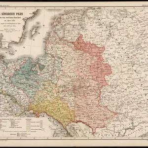
Map / Europe / Germany 18C
Showing the end of the old German Empire and the reconstruction of the German States, 1791 - 1815
Mary Evans Picture Library makes available wonderful images created for people to enjoy over the centuries
Media ID 4335685
© Mary Evans Picture Library 2015 - https://copyrighthub.org/s0/hub1/creation/maryevans/MaryEvansPictureID/10064864
20"x16" (+3" Border) Fine Art Print
Discover the rich history of Germany in the 18th century with our exquisite Fine Art Print from Media Storehouse, featuring the map "Map / Europe / Germany 1791-1815" by Rights Managed from Mary Evans Prints Online. This detailed and intricately designed map showcases the end of the Old German Empire and the subsequent reconstruction of German states during the Napoleonic Wars. A must-have for history enthusiasts and art collectors alike, this fine art print adds a touch of historical elegance to any room in your home or office.
20x16 image printed on 26x22 Fine Art Rag Paper with 3" (76mm) white border. Our Fine Art Prints are printed on 300gsm 100% acid free, PH neutral paper with archival properties. This printing method is used by museums and art collections to exhibit photographs and art reproductions.
Our fine art prints are high-quality prints made using a paper called Photo Rag. This 100% cotton rag fibre paper is known for its exceptional image sharpness, rich colors, and high level of detail, making it a popular choice for professional photographers and artists. Photo rag paper is our clear recommendation for a fine art paper print. If you can afford to spend more on a higher quality paper, then Photo Rag is our clear recommendation for a fine art paper print.
Estimated Image Size (if not cropped) is 49.4cm x 40.6cm (19.4" x 16")
Estimated Product Size is 66cm x 55.9cm (26" x 22")
These are individually made so all sizes are approximate
Artwork printed orientated as per the preview above, with landscape (horizontal) orientation to match the source image.
FEATURES IN THESE COLLECTIONS
> Europe
> Germany
> Related Images
> Europe
> Related Images
> Maps and Charts
> Early Maps
> Maps and Charts
> Related Images
EDITORS COMMENTS
This print showcases a historical map of Europe, specifically Germany in the 18th century. The map provides a fascinating glimpse into the end of the old German Empire and the subsequent reconstruction of the German states between 1791 and 1815.
The intricate details on this map highlight the complex political landscape of that time period, with borders shifting and territories being reorganized. It serves as a valuable visual representation of a pivotal moment in European history when power dynamics were evolving and new alliances were forming.
As we study this map, we can't help but be drawn into the story it tells about Germany's journey towards modernization and unity. The meticulous craftsmanship evident in every line and label is a testament to the cartographer's skill and dedication to accuracy.
For history buffs and enthusiasts alike, this print is sure to spark curiosity and inspire further exploration into the events that shaped Germany during this transformative era. It serves as both an educational tool and a work of art, offering viewers a window into the past like never before.
MADE IN THE USA
Safe Shipping with 30 Day Money Back Guarantee
FREE PERSONALISATION*
We are proud to offer a range of customisation features including Personalised Captions, Color Filters and Picture Zoom Tools
SECURE PAYMENTS
We happily accept a wide range of payment options so you can pay for the things you need in the way that is most convenient for you
* Options may vary by product and licensing agreement. Zoomed Pictures can be adjusted in the Cart.