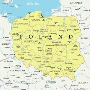
Canvas Print > Europe > Poland > Maps
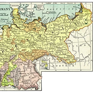
Canvas Print : Map / Europe / Germany 1871


![]()
Canvas Prints from Mary Evans Picture Library
Map / Europe / Germany 1871
Imperial Germany after the Franco- Prussian War, showing Alsace and Lorraine as part of the country, not to mention huge chunks of Poland in East Prussia
Mary Evans Picture Library makes available wonderful images created for people to enjoy over the centuries
Media ID 594581
© Mary Evans Picture Library 2015 - https://copyrighthub.org/s0/hub1/creation/maryevans/MaryEvansPictureID/10046923
1871 Alsace Franco Huge Lorraine Maps Mention Poland Prussia Prussian Chunks
20"x16" (51x41cm) Canvas Print
Introducing the captivating "Map / Europe / Germany 1871" canvas print from our Media Storehouse collection, brought to you by Mary Evans Picture Library via Mary Evans Prints Online. This intriguing historical piece showcases an imperial map of Europe during the aftermath of the Franco-Prussian War. The meticulously detailed illustration depicts Germany in its expanded form, with the annexation of Alsace and Lorraine, as well as substantial territories of Poland within East Prussia. Perfectly capturing the essence of Imperial Germany, this canvas print is a stunning addition to any home or office, evoking a sense of history and sophistication. Bring the past to life with this exquisite and thought-provoking piece.
Delivered stretched and ready to hang our premium quality canvas prints are made from a polyester/cotton blend canvas and stretched over a 1.25" (32mm) kiln dried knot free wood stretcher bar. Packaged in a plastic bag and secured to a cardboard insert for safe transit.
Canvas Prints add colour, depth and texture to any space. Professionally Stretched Canvas over a hidden Wooden Box Frame and Ready to Hang
Estimated Product Size is 50.8cm x 40.6cm (20" x 16")
These are individually made so all sizes are approximate
Artwork printed orientated as per the preview above, with landscape (horizontal) orientation to match the source image.
FEATURES IN THESE COLLECTIONS
> Europe
> Poland
> Related Images
> Europe
> Related Images
> Maps and Charts
> Early Maps
> Maps and Charts
> Related Images
> Mary Evans Prints Online
> Maps
EDITORS COMMENTS
This historic map print, sourced from Mary Evans Picture Library, offers a captivating glimpse into Imperial Germany in the year 1871, following the Franco-Prussian War. The map meticulously illustrates the significant territorial expansions achieved by Germany during this period, with the annexation of Alsace and Lorraine prominently displayed in the southwest, previously French territories that became German provinces after the war's conclusion. The map also highlights the extensive territorial gains in the east, particularly in the region of East Prussia, where large chunks of present-day Poland are depicted as part of the German Empire. The Prussian provinces of Posen, West Prussia, and Silesia are also clearly marked, reflecting the vast expansion of German influence and control. The map's historical significance lies in its accurate representation of the political landscape of Europe during this pivotal moment in history. The Franco-Prussian War, which lasted from 1870 to 1871, marked the end of the Second French Empire and the rise of the German Empire under the leadership of Otto von Bismarck. This map serves as a visual testament to the profound impact of the war on the European political landscape, reshaping the borders and alliances that would endure for decades to come. The intricate details of this map, from the precise labeling of cities and rivers to the delineation of various territories, offer a fascinating window into the past, inviting viewers to explore the rich history of Europe and the complex web of political relationships that have shaped the continent over the centuries.
MADE IN THE USA
Safe Shipping with 30 Day Money Back Guarantee
FREE PERSONALISATION*
We are proud to offer a range of customisation features including Personalised Captions, Color Filters and Picture Zoom Tools
SECURE PAYMENTS
We happily accept a wide range of payment options so you can pay for the things you need in the way that is most convenient for you
* Options may vary by product and licensing agreement. Zoomed Pictures can be adjusted in the Cart.