Canvas Print > Europe > Russia > Maps
Canvas Print : Map / Europe / Russia Empire


![]()
Canvas Prints from Mary Evans Picture Library
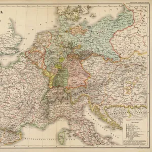
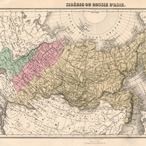
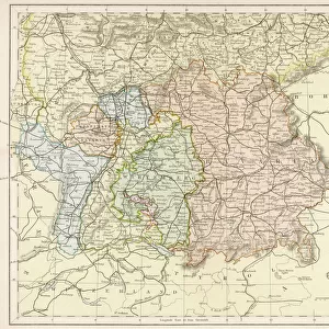
Map / Europe / Russia Empire
Map of the Russian Empire
Mary Evans Picture Library makes available wonderful images created for people to enjoy over the centuries
Media ID 608825
© Mary Evans Picture Library 2015 - https://copyrighthub.org/s0/hub1/creation/maryevans/MaryEvansPictureID/10114107
20"x16" (51x41cm) Canvas Print
Discover the grandeur of history with our exquisite Canvas Prints from Media Storehouse, featuring the captivating "Map / Europe / Russia Empire" image from Mary Evans Picture Library. This masterpiece, sourced from Mary Evans Prints Online, showcases the vast expanse of the Russian Empire in Europe during its historical peak. Each Canvas Print is meticulously crafted with premium materials, ensuring vibrant colors and stunning detail that bring history to life in your home or office. Elevate your interior décor with this impressive and educational piece, a conversation starter that tells a story of history, culture, and power.
Delivered stretched and ready to hang our premium quality canvas prints are made from a polyester/cotton blend canvas and stretched over a 1.25" (32mm) kiln dried knot free wood stretcher bar. Packaged in a plastic bag and secured to a cardboard insert for safe transit.
Canvas Prints add colour, depth and texture to any space. Professionally Stretched Canvas over a hidden Wooden Box Frame and Ready to Hang
Estimated Product Size is 50.8cm x 40.6cm (20" x 16")
These are individually made so all sizes are approximate
Artwork printed orientated as per the preview above, with landscape (horizontal) orientation to match the source image.
FEATURES IN THESE COLLECTIONS
> Europe
> Related Images
> Europe
> Russia
> Related Images
> Maps and Charts
> Early Maps
> Maps and Charts
> Related Images
EDITORS COMMENTS
This stunning print captures a piece of history with its detailed depiction of the Russian Empire in Europe. The map showcases the vast expanse of land that once belonged to this powerful empire, stretching from Eastern Europe all the way to Siberia and beyond.
The intricate details on the map provide a glimpse into the historical boundaries and territories that defined Russia during this time period. From major cities to geographical features, every aspect is meticulously illustrated, giving viewers a sense of the sheer size and influence of the Russian Empire.
As we study this map, we are transported back in time to an era when Russia was one of the most dominant forces in Europe. Its rich history and cultural heritage are evident in every corner of this expansive empire.
Whether you have a personal connection to Russia or simply appreciate historical maps, this print is sure to captivate your imagination. It serves as a reminder of a bygone era when empires ruled over vast lands and shaped the course of history.
Add this unique piece from Mary Evans Picture Library to your collection today and let it transport you back in time to explore the grandeur and complexity of the Russian Empire.
MADE IN THE USA
Safe Shipping with 30 Day Money Back Guarantee
FREE PERSONALISATION*
We are proud to offer a range of customisation features including Personalised Captions, Color Filters and Picture Zoom Tools
SECURE PAYMENTS
We happily accept a wide range of payment options so you can pay for the things you need in the way that is most convenient for you
* Options may vary by product and licensing agreement. Zoomed Pictures can be adjusted in the Cart.