Canvas Print > North America > Mexico > Maps
Canvas Print : Map of Caribbean


![]()
Canvas Prints from Mary Evans Picture Library
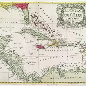
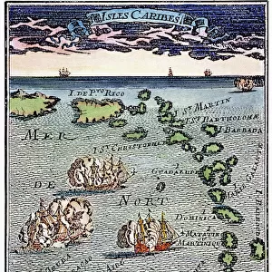
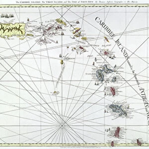
Map of Caribbean
The Caribbean, with the West Indies, and the coasts of the United States and the Spanish possessions which later became Texas and Mexico, and the northern coast of S. America
Mary Evans Picture Library makes available wonderful images created for people to enjoy over the centuries
Media ID 603487
© Mary Evans Picture Library 2015 - https://copyrighthub.org/s0/hub1/creation/maryevans/MaryEvansPictureID/10126262
Caribbean Coasts Indies Maps Mexico Possessions Texas
20"x16" (51x41cm) Canvas Print
Introducing the stunning "Map of the Caribbean" Canvas Print from the Media Storehouse collection, brought to you by Mary Evans Picture Library through Mary Evans Prints Online. This captivating piece transports you to a time when exploration and discovery were at the forefront of human endeavor. The intricate detail of this antique map showcases the Caribbean Sea, the West Indies, and the coasts of the United States, Mexico, and South America. Each canvas print is meticulously crafted using premium materials and high-definition printing techniques, ensuring a vibrant and detailed representation of this historic cartographic masterpiece. Elevate your home or office décor with this beautiful and educational addition to your space.
Delivered stretched and ready to hang our premium quality canvas prints are made from a polyester/cotton blend canvas and stretched over a 1.25" (32mm) kiln dried knot free wood stretcher bar. Packaged in a plastic bag and secured to a cardboard insert for safe transit.
Canvas Prints add colour, depth and texture to any space. Professionally Stretched Canvas over a hidden Wooden Box Frame and Ready to Hang
Estimated Image Size (if not cropped) is 50.8cm x 36.3cm (20" x 14.3")
Estimated Product Size is 50.8cm x 40.6cm (20" x 16")
These are individually made so all sizes are approximate
Artwork printed orientated as per the preview above, with landscape (horizontal) orientation to match the source image.
FEATURES IN THESE COLLECTIONS
> Europe
> Spain
> Related Images
> Maps and Charts
> Early Maps
> Maps and Charts
> Related Images
> Maps and Charts
> Spain
> North America
> Mexico
> Maps
> North America
> Mexico
> Related Images
EDITORS COMMENTS
This stunning historical map of the Caribbean, created in the late 18th century, offers a fascinating glimpse into the past. The intricate details depict not only the islands of the Caribbean and the West Indies but also the coasts of what would later become Texas and Mexico, as well as the northern coast of South America.
The Spanish possessions are clearly marked on this map, showcasing their influence in this region during that time period. The United States is also featured prominently, highlighting its proximity to these territories.
As we study this map, we can't help but marvel at how much has changed since it was first drawn. The borders have shifted, new nations have emerged, and cultures have evolved over time. It serves as a reminder of our ever-changing world and how history continues to shape our present-day reality.
This print from Mary Evans Picture Library is not just a piece of art; it's a valuable historical document that allows us to connect with the past and gain a deeper understanding of the complex interplay between different nations and regions. It's truly a treasure for anyone interested in history or geography.
MADE IN THE USA
Safe Shipping with 30 Day Money Back Guarantee
FREE PERSONALISATION*
We are proud to offer a range of customisation features including Personalised Captions, Color Filters and Picture Zoom Tools
SECURE PAYMENTS
We happily accept a wide range of payment options so you can pay for the things you need in the way that is most convenient for you
* Options may vary by product and licensing agreement. Zoomed Pictures can be adjusted in the Cart.