Home > Maps and Charts > British Empire Maps
Photo Mug : World Map Empire McVitie


Home Decor from Mary Evans Picture Library
World Map Empire McVitie
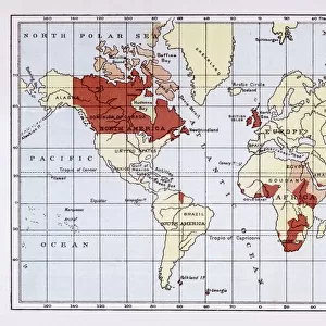
A map of the world, showing the British Empire coloured in red at the end of the nineteenth century
Mary Evans Picture Library makes available wonderful images created for people to enjoy over the centuries
Media ID 592741
© Mary Evans Picture Library 2015 - https://copyrighthub.org/s0/hub1/creation/maryevans/MaryEvansPictureID/10041931
Colonialism Dominions Imperialism Maps Mcvitie Patriotism Power Territory
Photo Mug (11 oz)
Introducing the Media Storehouse Photo Mug, a perfect blend of history and functionality. This unique mug showcases an intriguing image from Mary Evans Picture Library, "World Map Empire McVitie." Witness the expansive reach of the British Empire at the turn of the twentieth century, as depicted in this vivid, detailed map. Each sip from this mug transports you back in time, making it an exceptional addition to your morning routine or as a thoughtful gift. Embrace the past while enjoying your favorite beverage in style.
A personalized photo mug blends sentimentality with functionality, making an ideal gift for cherished loved ones, close friends, or valued colleagues. Preview may show both sides of the same mug.
Elevate your coffee or tea experience with our premium white ceramic mug. Its wide, comfortable handle makes drinking easy, and you can rely on it to be both microwave and dishwasher safe. Sold in single units, preview may show both sides of the same mug so you can see how the picture wraps around.
Mug Size is 8cm high x 9.5cm diameter (3.1" x 3.7")
These are individually made so all sizes are approximate
FEATURES IN THESE COLLECTIONS
> Maps and Charts
> British Empire Maps
> Maps and Charts
> Early Maps
> Maps and Charts
> World
> Mary Evans Prints Online
> Maps
EDITORS COMMENTS
This striking print of the "World Map Empire McVitie" offers a glimpse into the vast and powerful British Empire at the end of the nineteenth century. The map, colored in bold red to signify British territory, showcases the extent of imperialism and colonialism during this period in history.
The map is a testament to Britain's dominance and influence across the globe, with its various dominions highlighted for all to see. It serves as a reminder of the immense power that Britain held during this time, as well as the impact it had on shaping world events.
As we study this historical artifact, we are transported back to a time when patriotism and national pride were closely tied to notions of empire building and expansion. The map symbolizes not only British strength and authority but also serves as a reflection of global politics and relationships during the late 19th century.
Through examining this map, we gain valuable insights into how historical events have shaped our world today. It is a visual representation of an era marked by ambition, conquest, and territorial control - elements that continue to resonate in our modern society.
Overall, "World Map Empire McVitie" is more than just a geographical depiction; it is a window into an important chapter in human history that continues to inform our understanding of power dynamics and international relations.
MADE IN THE USA
Safe Shipping with 30 Day Money Back Guarantee
FREE PERSONALISATION*
We are proud to offer a range of customisation features including Personalised Captions, Color Filters and Picture Zoom Tools
SECURE PAYMENTS
We happily accept a wide range of payment options so you can pay for the things you need in the way that is most convenient for you
* Options may vary by product and licensing agreement. Zoomed Pictures can be adjusted in the Cart.