Home > Africa > Libya > Maps
Photographic Print : World Map / Crates Mallos


![]()
Photo Prints from Mary Evans Picture Library
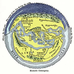
World Map / Crates Mallos
A world map according to Crates of Mallos, showing Europe, Libya, the Antipodes, and various seas Date: circa 168 BC
Mary Evans Picture Library makes available wonderful images created for people to enjoy over the centuries
Media ID 7124621
© Mary Evans Picture Library 2015 - https://copyrighthub.org/s0/hub1/creation/maryevans/MaryEvansPictureID/10113657
Antipodes Crates Libya Maps Seas Mallos
14"x11" Photo Print
Discover a captivating blend of ancient cartography and artistic mastery with our Media Storehouse range of Photographic Prints featuring "World Map / Crates Mallos" by Rights Managed from Mary Evans Prints Online. This mesmerizing antique map, believed to be circa 168 BC, offers a unique perspective of the known world during ancient times. Depicting Europe, Libya, the Antipodes, and various seas, this intricately detailed map provides a fascinating glimpse into the geographical knowledge and artistic expression of the past. Elevate your home or office decor with this beautiful and educational addition, and transport yourself on a journey through history.
Photo prints are produced on Kodak professional photo paper resulting in timeless and breath-taking prints which are also ideal for framing. The colors produced are rich and vivid, with accurate blacks and pristine whites, resulting in prints that are truly timeless and magnificent. Whether you're looking to display your prints in your home, office, or gallery, our range of photographic prints are sure to impress. Dimensions refers to the size of the paper in inches.
Our Photo Prints are in a large range of sizes and are printed on Archival Quality Paper for excellent colour reproduction and longevity. They are ideal for framing (our Framed Prints use these) at a reasonable cost. Alternatives include cheaper Poster Prints and higher quality Fine Art Paper, the choice of which is largely dependant on your budget.
Estimated Product Size is 27.9cm x 35.5cm (11" x 14")
These are individually made so all sizes are approximate
Artwork printed orientated as per the preview above, with portrait (vertical) orientation to match the source image.
FEATURES IN THESE COLLECTIONS
> Africa
> Libya
> Related Images
> Maps and Charts
> World
EDITORS COMMENTS
This intriguing world map, dated circa 168 BC, is based on the descriptions of the ancient Greek philosopher and geographer Crates of Mallos. The map depicts the known world as it was understood during the Hellenistic period, with a focus on Europe, Libya, and the Antipodes. Crates of Mallos was a renowned scholar from Pergamon in Asia Minor, who is believed to have lived around the second century BC. He is best known for his contributions to geography and cartography, having written several works on the subject. This map, which is one of the earliest surviving examples of a world map from the ancient world, is based on his descriptions. The map shows Europe in its entirety, with the Mediterranean Sea to the south and the Atlantic Ocean to the west. To the south, the African continent is depicted as Libya, with the Nile River running through it. The Red Sea and the Indian Ocean are also shown, with the Antipodes, or the lands located on the opposite side of the world, indicated in the southern hemisphere. The map is notable for its accurate depiction of the Mediterranean Sea and the Black Sea, as well as the correct placement of the Iberian Peninsula and the British Isles. It also shows the location of several ancient cities, such as Rome, Carthage, and Alexandria. Despite its age and the limitations of the technology available at the time, this map is a remarkable testament to the intellectual curiosity and cartographic skills of the ancient world. It offers a fascinating glimpse into the geographical knowledge of the time and the ways in which the ancient Greeks and Romans understood the world around them.
MADE IN THE USA
Safe Shipping with 30 Day Money Back Guarantee
FREE PERSONALISATION*
We are proud to offer a range of customisation features including Personalised Captions, Color Filters and Picture Zoom Tools
SECURE PAYMENTS
We happily accept a wide range of payment options so you can pay for the things you need in the way that is most convenient for you
* Options may vary by product and licensing agreement. Zoomed Pictures can be adjusted in the Cart.