Home > Europe > Greece > Maps
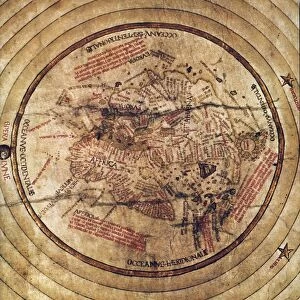
Photographic Print : World Map c. 50BC


![]()
Photo Prints from Mary Evans Picture Library
World Map c. 50BC
World Map according to Poseidonius, Greece
Mary Evans Picture Library makes available wonderful images created for people to enjoy over the centuries
Media ID 570608
© Mary Evans Picture Library 2015 - https://copyrighthub.org/s0/hub1/creation/maryevans/MaryEvansPictureID/10001208
14"x11" Photo Print
Discover the fascinating historical detail of ancient geography with our exclusive range of Photographic Prints from Mary Evans Picture Library. This captivating image depicts a World Map, believed to have been created around 50BC, according to the renowned Greek scholar Poseidonius. Witness the intriguing differences between the ancient and modern world, as you bring a piece of history into your home or office. The high-quality print, sourced from Mary Evans Prints Online, offers vibrant colors and exceptional detail, ensuring a stunning addition to any space. Immerse yourself in the rich history of cartography and expand your knowledge with this unique and intriguing piece.
Photo prints are produced on Kodak professional photo paper resulting in timeless and breath-taking prints which are also ideal for framing. The colors produced are rich and vivid, with accurate blacks and pristine whites, resulting in prints that are truly timeless and magnificent. Whether you're looking to display your prints in your home, office, or gallery, our range of photographic prints are sure to impress. Dimensions refers to the size of the paper in inches.
Our Photo Prints are in a large range of sizes and are printed on Archival Quality Paper for excellent colour reproduction and longevity. They are ideal for framing (our Framed Prints use these) at a reasonable cost. Alternatives include cheaper Poster Prints and higher quality Fine Art Paper, the choice of which is largely dependant on your budget.
Estimated Image Size (if not cropped) is 35.5cm x 18.9cm (14" x 7.4")
Estimated Product Size is 35.5cm x 27.9cm (14" x 11")
These are individually made so all sizes are approximate
Artwork printed orientated as per the preview above, with landscape (horizontal) orientation to match the source image.
FEATURES IN THESE COLLECTIONS
> Maps and Charts
> Early Maps
> Maps and Charts
> World
EDITORS COMMENTS
This stunning print captures a piece of ancient history with the World Map according to Poseidonius, Greece, dating back to around 50BC. Created during the early 1st century by the Greek philosopher and geographer Poseidonius, this map offers a fascinating glimpse into how people viewed the world over two thousand years ago.
The intricate details and craftsmanship of this map showcase the knowledge and skills of ancient cartographers. From Europe to Africa to Asia, every corner of the known world is depicted with remarkable accuracy considering the limited technology available at that time.
As we gaze upon this historical artifact, we are transported back in time to an era when exploration and discovery were at their peak. The lines and symbols on this map tell stories of trade routes, cultural exchanges, and geopolitical boundaries that shaped civilizations in antiquity.
It's truly incredible to think about how far we've come in terms of mapping our planet since Poseidonius first drew his interpretation of it. This print serves as a reminder of our shared human history and the endless possibilities for exploration and understanding that still lie ahead.
MADE IN THE USA
Safe Shipping with 30 Day Money Back Guarantee
FREE PERSONALISATION*
We are proud to offer a range of customisation features including Personalised Captions, Color Filters and Picture Zoom Tools
SECURE PAYMENTS
We happily accept a wide range of payment options so you can pay for the things you need in the way that is most convenient for you
* Options may vary by product and licensing agreement. Zoomed Pictures can be adjusted in the Cart.