Framed Print : World Map c. 50BC


![]()
Framed Photos from Mary Evans Picture Library
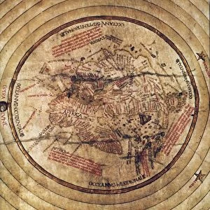
World Map c. 50BC
World Map according to Poseidonius, Greece
Mary Evans Picture Library makes available wonderful images created for people to enjoy over the centuries
Media ID 570608
© Mary Evans Picture Library 2015 - https://copyrighthub.org/s0/hub1/creation/maryevans/MaryEvansPictureID/10001208
22"x18" Modern Frame
Discover the rich history of ancient geography with our stunning Framed Prints from Media Storehouse, featuring the captivating "World Map c. 50BC" by Mary Evans Picture Library. This exquisite print showcases the world as it was known to the ancient Greeks, based on the geographical knowledge of Poseidonius. Transport yourself back in time as you admire the intricate details of this historical map, meticulously crafted and beautifully framed. A perfect addition to any home or office, this Framed Print is not only a beautiful decor piece but also an educational investment, inspiring curiosity and appreciation for the world's fascinating history. Order yours today and bring a piece of the past into your present.
20x16 Print in an MDF Wooden Frame with 180 gsm Satin Finish Paper. Glazed using shatter proof thin plexiglass. Frame thickness is 1 inch and depth 0.75 inch. Fluted cardboard backing held with clips. Supplied ready to hang with sawtooth hanger and rubber bumpers. Spot clean with a damp cloth. Packaged foam wrapped in a card.
Contemporary Framed and Mounted Prints - Professionally Made and Ready to Hang
Estimated Image Size (if not cropped) is 50.8cm x 45.7cm (20" x 18")
Estimated Product Size is 55.9cm x 45.7cm (22" x 18")
These are individually made so all sizes are approximate
Artwork printed orientated as per the preview above, with landscape (horizontal) orientation to match the source image.
EDITORS COMMENTS
This stunning print captures a piece of ancient history with the World Map according to Poseidonius, Greece, dating back to around 50BC. Created during the early 1st century by the Greek philosopher and geographer Poseidonius, this map offers a fascinating glimpse into how people viewed the world over two thousand years ago.
The intricate details and craftsmanship of this map showcase the knowledge and skills of ancient cartographers. From Europe to Africa to Asia, every corner of the known world is depicted with remarkable accuracy considering the limited technology available at that time.
As we gaze upon this historical artifact, we are transported back in time to an era when exploration and discovery were at their peak. The lines and symbols on this map tell stories of trade routes, cultural exchanges, and geopolitical boundaries that shaped civilizations in antiquity.
It's truly incredible to think about how far we've come in terms of mapping our planet since Poseidonius first drew his interpretation of it. This print serves as a reminder of our shared human history and the endless possibilities for exploration and understanding that still lie ahead.
MADE IN THE USA
Safe Shipping with 30 Day Money Back Guarantee
FREE PERSONALISATION*
We are proud to offer a range of customisation features including Personalised Captions, Color Filters and Picture Zoom Tools
SECURE PAYMENTS
We happily accept a wide range of payment options so you can pay for the things you need in the way that is most convenient for you
* Options may vary by product and licensing agreement. Zoomed Pictures can be adjusted in the Cart.